IMAGES TAKEN NEAR TO
Franklin Road, BIRMINGHAM, B30 2EJ
Introduction
This page details the photographs taken nearby to Franklin Road, B30 2EJ by members of the Geograph project.
The Geograph project started in 2005 with the aim of publishing, organising and preserving representative images for every square kilometre of Great Britain, Ireland and the Isle of Man.

There are currently over 7.5m images from over14,400 individuals and you can help contribute to the project by visiting https://www.geograph.org.uk
Image Map
Images are licensed for reuse under creativecommons.org/licenses/by-sa/2.0
Notes
- Clicking on the map will re-center to the selected point.
- The higher the marker number, the further away the image location is from the centre of the postcode.
Image Listing (4 Images Found)
Images are licensed for reuse under creativecommons.org/licenses/by-sa/2.0
Image
Details
Distance
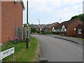
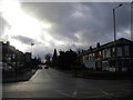
2
Rowheath Road, Cotteridge
Seen from near the junction with Watford Road.
Image: © Richard Vince
Taken: 10 Mar 2018
0.23 miles
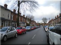
3
East end of Northfield Road, Cotteridge
Seen from Watford Road.
Image: © Richard Vince
Taken: 10 Mar 2018
0.23 miles
4
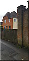
Brick Pillar with cut Benchmark
The pillar is on the northwest corner of the grounds of Kings Norton Girls' School.
Image: © Paul Collins
Taken: 7 Jan 2023
0.24 miles