IMAGES TAKEN NEAR TO
Mary Vale Road, BIRMINGHAM, B30 2DN
Introduction
This page details the photographs taken nearby to Mary Vale Road, B30 2DN by members of the Geograph project.
The Geograph project started in 2005 with the aim of publishing, organising and preserving representative images for every square kilometre of Great Britain, Ireland and the Isle of Man.

There are currently over 7.5m images from over14,400 individuals and you can help contribute to the project by visiting https://www.geograph.org.uk
Image Map
Images are licensed for reuse under creativecommons.org/licenses/by-sa/2.0
Notes
- Clicking on the map will re-center to the selected point.
- The higher the marker number, the further away the image location is from the centre of the postcode.
Image Listing (125 Images Found)
Images are licensed for reuse under creativecommons.org/licenses/by-sa/2.0
Image
Details
Distance
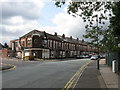
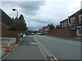
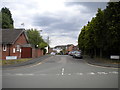
2
Bournville Social Club
Junction of Franklin road and Mary Vale Road.
Image: © JThomas
Taken: 22 Jul 2017
0.06 miles
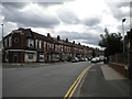
3
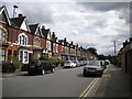
Franklin Road, Bournville
Seen from near the junction with Mary Vale Road.
Image: © Richard Vince
Taken: 14 Jul 2017
0.07 miles
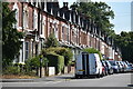
7
North end of Franklin Road, Bournville
Looking towards its junction with Mary Vale Road.
Image: © Richard Vince
Taken: 14 Jul 2017
0.07 miles
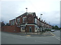
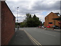
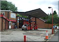
8
Mary Vale Service Station
Confusingly located on Franklin Road, at its junction with Mary Vale Road.
Image: © Peter Whatley
Taken: 13 Sep 2008
0.07 miles
9
Selly Hall Croft, Bournville
Off Franklin Road.
Image: © Richard Vince
Taken: 14 Jul 2017
0.08 miles
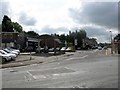
10
Service station on Franklin Road, Bournville
Image: © JThomas
Taken: 22 Jul 2017
0.08 miles