IMAGES TAKEN NEAR TO
Willow Road, BIRMINGHAM, B30 2AT
Introduction
This page details the photographs taken nearby to Willow Road, B30 2AT by members of the Geograph project.
The Geograph project started in 2005 with the aim of publishing, organising and preserving representative images for every square kilometre of Great Britain, Ireland and the Isle of Man.

There are currently over 7.5m images from over14,400 individuals and you can help contribute to the project by visiting https://www.geograph.org.uk
Image Map
Images are licensed for reuse under creativecommons.org/licenses/by-sa/2.0
Notes
- Clicking on the map will re-center to the selected point.
- The higher the marker number, the further away the image location is from the centre of the postcode.
Image Listing (135 Images Found)
Images are licensed for reuse under creativecommons.org/licenses/by-sa/2.0
Image
Details
Distance
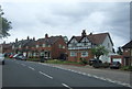
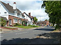
2
Willow Road looking north - Bournville, Birmingham
A view looking northwards along Willow Road from Laburnum Road. The Cadburys opened their factory in 1879 and embarked on a programme of house building for their workers and 143 cottages were built to the design of architect George Gadd. In 1900 George Cadbury formed the Bournville Village Trust and these houses date from the early 1900s - the architect was William Harvey. The First World War memorial was placed here in 1923. The influence of the Cadburys still persists - there is no pub in Bournville. In 2010 the City Council removed a number of trees from Willow Road and failed to replace them on grounds of cost, to the great disgust of residents. Time photo taken 2.22 pm BST (British Summer Time).
Image: © Martin Richard Phelan
Taken: 2 Apr 2011
0.07 miles
3
Sycamore Road northern end - Bournville, Birmingham
A view north west from Laburnum Road across to where Sycamore Road joins Willow Road. The Cadburys opened their factory in 1879 and embarked on a programme of house building for their workers and 143 cottages were built to the design of architect George Gadd. In 1900 George Cadbury formed the Bournville Village Trust and these houses date from the early 1900s - the architect was William Harvey. The First World War memorial was placed here in 1923. The influence of the Cadburys still persists - there is no pub in Bournville. In 2010 the City Council removed a number of trees from Willow Road and failed to replace them on grounds of cost, to the great disgust of residents. Time photo taken 2.23 pm BST (British Summer Time).
Image: © Martin Richard Phelan
Taken: 2 Apr 2011
0.07 miles
4
Elm Road, Bournville
Looking in the direction of Raddlebarn Road.
Image: © Phil Champion
Taken: 14 Jan 2007
0.08 miles
5
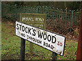
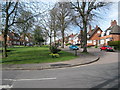
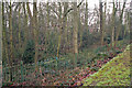
Street nameplate at Stock's Wood, Bournville
Stock's Wood is both the name of the private road and the wood behind. The area of woodland predates the building of the garden suburb that now surrounds it, and was previously larger. The 25" Ordnance Survey map from the late 19th century gives the name Stock's Wood, also showing earthworks on the east side near Five Gates Farm. This 'camp' was destroyed when Willow Road was built, but survives in the name of the wood given on later maps.
An information board nearby suggests the wood might be a surviving remnant of the ancient Forest of Arden, all notes that no trees within the wood are particularly old. The site is managed as a nature reserve and is designated a Site of Local Importance for Nature Conservation (SLINC). There is no public access - but Bournville has an abundance of other green spaces.
Image: © Phil Champion
Taken: 22 Jan 2006
0.08 miles
6
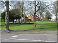
Acacia Road and Stocks Wood / Camp Wood, Bournville
This area of woodland predates the building of the garden suburb that now surrounds it, and was previously larger. The 25" Ordnance Survey map gives the name Stock's Wood, also showing earthworks on the east side near Five Gates Farm. This 'camp' was destroyed when Willow Road was built, but survives in the name of the wood given on later maps.
An information board nearby suggests the wood might be a surviving remnant of the ancient Forest of Arden, all notes that no trees within the wood are particularly old. The site is managed as a nature reserve and is designated a Site of Local Importance for Nature Conservation (SLINC). There is no public access - but Bournville has an abundance of other green spaces.
Image: © Phil Champion
Taken: 22 Jan 2006
0.09 miles
7
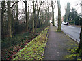
On Laburnum Road - Bournville, Birmingham
View from Laburnum Road at its junction with Sycamore Road looking northwards into Willow Road beyond its junction with Sycamore Road. The Cadburys opened their factory in 1879 and embarked on a programme of house building for their workers and 143 cottages were built to the design of architect George Gadd. In 1900 George Cadbury formed the Bournville Village Trust and these houses date from the early 1900s - the architect was William Harvey. The influence of the Cadburys still persists - there is no pub in Bournville. Time photo taken 2.25 pm BST (British Summer Time).
Image: © Martin Richard Phelan
Taken: 2 Apr 2011
0.09 miles
8
Grass from chocolate 1 - Bournville, Birmingham
Three views in Willow Road, Bournville. The Cadburys opened their factory in 1879 and embarked on a programme of house building for their workers and 143 cottages were built to the design of architect George Gadd. In 1900 George Cadbury formed the Bournville Village Trust and these houses date from the early 1900s - the architect was William Harvey. The influence of the Cadburys still persists - there is no pub in Bournville. In 2010 the City Council removed a number of trees from Willow Road and failed to replace them on grounds of cost, to the great disgust of residents. Time photo taken 2.18 pm BST (British Summer Time).
Image Image
Image: © Martin Richard Phelan
Taken: 2 Apr 2011
0.09 miles
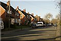
9
Houses in Sycamore Road going into Willow Road, Bournville, Birmingham
Image: © Ruth Sharville
Taken: 13 Jun 2011
0.10 miles
10
Stocks Wood / Camp Wood, Bournville
This area of woodland predates the building of the garden suburb that now surrounds it, and was previously larger. The 25" Ordnance Survey map gives the name Stock's Wood, also showing earthworks on the east side near Five Gates Farm. This 'camp' was destroyed when Willow Road was built, but survives in the name of the wood given on later maps.
An information board nearby suggests the wood might be a surviving remnant of the ancient Forest of Arden, all notes that no trees within the wood are particularly old. The site is managed as a nature reserve and is designated a Site of Local Importance for Nature Conservation (SLINC). There is no public access - but Bournville has an abundance of other green spaces that the public can use.
Image: © Phil Champion
Taken: 22 Jan 2006
0.10 miles