IMAGES TAKEN NEAR TO
Linnet Close, BIRMINGHAM, B30 1XB
Introduction
This page details the photographs taken nearby to Linnet Close, B30 1XB by members of the Geograph project.
The Geograph project started in 2005 with the aim of publishing, organising and preserving representative images for every square kilometre of Great Britain, Ireland and the Isle of Man.

There are currently over 7.5m images from over14,400 individuals and you can help contribute to the project by visiting https://www.geograph.org.uk
Image Map
Images are licensed for reuse under creativecommons.org/licenses/by-sa/2.0
Notes
- Clicking on the map will re-center to the selected point.
- The higher the marker number, the further away the image location is from the centre of the postcode.
Image Listing (15 Images Found)
Images are licensed for reuse under creativecommons.org/licenses/by-sa/2.0
Image
Details
Distance
1
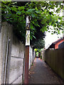
Remains of a pre-Worboys "Cycling Prohibited" sign
Spotted on a footpath leading off Oak Tree Lane, Bournville. There is a modern sign at the Linden Road end of the path. Update - February 2012: This has since been replaced with a modern no cycling sign.
Image: © Phil Champion
Taken: 23 Apr 2011
0.14 miles
2
Former entrance to Elmfield House, Selly Oak
A disused University of Birmingham building just off Bristol Road. The burgundy sign next to the door reads "English for International Students Unit (EISU) Selly Oak".
Image: © Richard Vince
Taken: 9 Jul 2022
0.16 miles
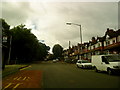
3
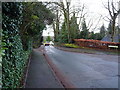
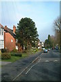
Oak Tree Lane in Bournville
A rather narrow part of Oak Tree Lane, forcing some 'give way' action upon the cars heading north.
Image: © Richard Law
Taken: 16 Dec 2019
0.17 miles
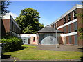
4
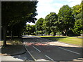
College Walk, Selly Oak
Looking towards Bristol Road.
Image: © Richard Vince
Taken: 9 Jul 2022
0.17 miles
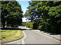
6
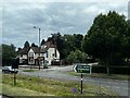
Bristol Road, Selly Oak
Looking towards Northfield in the vicinity of the University of Birmingham's Selly Oak campus. The broad central reservation was once home to tramlines.
Image: © Richard Vince
Taken: 9 Jul 2022
0.18 miles
7
Oakville Dental, Selly Oak
At 968 Bristol Road.
Image: © Andrew Abbott
Taken: 14 Jul 2024
0.21 miles
8
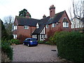
172 Oak Tree Lane, Bournville
Dated to 1907, and built to a Domestic Revival design by the architect W. Alexander Harvey as part of the extensive Bournville Estate. It was Grade II listed https://britishlistedbuildings.co.uk/101033366-172-oak-tree-lane-bournville-ward#.Xi21FGj7TIU & https://historicengland.org.uk/listing/the-list/list-entry/1033366 in 1998, and the interior is noted for extensive wooden panelling and other details, apparently including a rather splendid open-well staircase.
Image: © Richard Law
Taken: 16 Dec 2019
0.22 miles
10

Coach House and garage to the south of no 172
Built at the same time as, and in a similar style to match the main adjacent Image and also Grade II listed https://britishlistedbuildings.co.uk/101271802-coach-house-and-garage-south-of-number-172-bournville-ward#.Xi22dGj7TIU & https://historicengland.org.uk/listing/the-list/list-entry/1271802 in 1998.
Image: © Richard Law
Taken: 16 Dec 2019
0.22 miles