IMAGES TAKEN NEAR TO
Oak Tree Lane, BIRMINGHAM, B30 1UH
Introduction
This page details the photographs taken nearby to Oak Tree Lane, B30 1UH by members of the Geograph project.
The Geograph project started in 2005 with the aim of publishing, organising and preserving representative images for every square kilometre of Great Britain, Ireland and the Isle of Man.

There are currently over 7.5m images from over14,400 individuals and you can help contribute to the project by visiting https://www.geograph.org.uk
Image Map
Images are licensed for reuse under creativecommons.org/licenses/by-sa/2.0
Notes
- Clicking on the map will re-center to the selected point.
- The higher the marker number, the further away the image location is from the centre of the postcode.
Image Listing (114 Images Found)
Images are licensed for reuse under creativecommons.org/licenses/by-sa/2.0
Image
Details
Distance
1
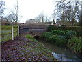
The Bourn runs under Selly Oak Road
At the western edge of Bournville Park, the River Bourn is draining from a pool in Manor Farm park and land to the west of there around Frankley. It runs eastwards from here to join the River Rea Image in the Stirchley area.
Image: © Richard Law
Taken: 16 Dec 2019
0.05 miles
2

St Georges Court
St Georges Court, a Georgian style building in Bournville. This was built in 1927 as service accommodation for young ladies who were effectively housemaids to those working all day. Traditionally women working at Cadbury's were expected to leave their work when they married, however, women who didn't married and continued working tended to employ the services of these house maids. Yes, I know the world of work has changed considerably since these times and in the 21st century such ideas are very un-pc. Today this building has been converted into single bedroom apartments.
Image: © Philip Halling
Taken: 30 Oct 2019
0.06 miles
4
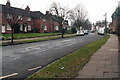
Houses on Hay Green Lane
Houses on Hay Green Lane in Bournville.
Image: © Philip Halling
Taken: 30 Oct 2019
0.08 miles
5
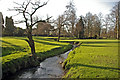
The Bourn flowing through Bournville Park
The stream continues through / under the chocolate factory to join the River Rea. This should not be confused with the Bourn Brook, which joins the Rea a mile or so further north.
Image: © Phil Champion
Taken: 14 Jan 2007
0.08 miles
6
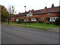
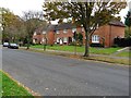
Houses on Hay Green Lane
Houses on Hay Green Lane in Bournville.
Image: © Philip Halling
Taken: 30 Oct 2019
0.09 miles
7
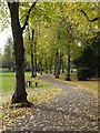
Tree-lined path through Bournville Park
Image: © Philip Halling
Taken: 30 Oct 2019
0.11 miles
8
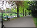
Way in to the park - Bournville, Birmingham
A view into Bournville Park, taken at the Linden Road entrance. Time photo taken 12.36 pm BST (British Summer Time).
Image: © Martin Richard Phelan
Taken: 17 Apr 2011
0.11 miles
9
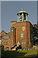
Junior School and Carillon, Bournville
Atop the Arts and Crafts style Bournville Junior School is a 48 bell carillon. George Cadbury was inspired to build the carillon after viewing one in Bruges, which dates back to 1675. The Bournville Carillon can be heard most weekends. The British Carillon Society website http://www.carillons.org/ lists 15 carillons, mostly working.
Image: © Phil Champion
Taken: 14 Jan 2007
0.12 miles
10

Coach House and garage to the south of no 172
Built at the same time as, and in a similar style to match the main adjacent Image and also Grade II listed https://britishlistedbuildings.co.uk/101271802-coach-house-and-garage-south-of-number-172-bournville-ward#.Xi22dGj7TIU & https://historicengland.org.uk/listing/the-list/list-entry/1271802 in 1998.
Image: © Richard Law
Taken: 16 Dec 2019
0.12 miles