IMAGES TAKEN NEAR TO
Griffins Brook Lane, BIRMINGHAM, B30 1QJ
Introduction
This page details the photographs taken nearby to Griffins Brook Lane, B30 1QJ by members of the Geograph project.
The Geograph project started in 2005 with the aim of publishing, organising and preserving representative images for every square kilometre of Great Britain, Ireland and the Isle of Man.

There are currently over 7.5m images from over14,400 individuals and you can help contribute to the project by visiting https://www.geograph.org.uk
Image Map
Images are licensed for reuse under creativecommons.org/licenses/by-sa/2.0
Notes
- Clicking on the map will re-center to the selected point.
- The higher the marker number, the further away the image location is from the centre of the postcode.
Image Listing (32 Images Found)
Images are licensed for reuse under creativecommons.org/licenses/by-sa/2.0
Image
Details
Distance
1

Pillar Box in Woodlands Park Road
This view looks west along Hay Green Lane, an old country lane. The houses visible are part of the Bournville Village Trust (BVT). Founded by George Cadbury in 1900, the estate now covers over 1000 acres and has almost 8000 houses.
Image: © Paul Collins
Taken: 18 Mar 2017
0.10 miles
3

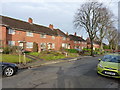
Bournville Village Trust (BVT) Houses
This view looks south along Woodlands Park Road. The houses visible are part of the Bournville Village Trust (BVT). Founded by George Cadbury in 1900, the estate now covers over 1000 acres and has almost 8000 houses. In general, the houses and open spaces seem to be well-maintained and offer an attractive place to be.
Image: © Paul Collins
Taken: 18 Mar 2017
0.13 miles
4
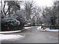
Hole Lane Northfield.
Hole Lane at the junction with the A38 Bristol Road South.
Image: © Roy Hughes
Taken: 3 Feb 2009
0.14 miles
5
Hay Green Methodist Church
The church is in Cob Lane, a rural lane which survived when this area began to be developed in the first half of the 20th century.
Image: © Paul Collins
Taken: 18 Mar 2017
0.14 miles
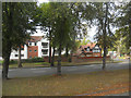

8
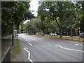
Bristol Road South, Northfield
The central reservation was formerly used by trams.
Image: © Richard Vince
Taken: 3 Sep 2022
0.15 miles
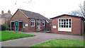
9
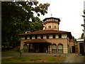
Parish hall at the Serbian Orthodox Church
Image: © Andrew Abbott
Taken: 17 Jul 2010
0.15 miles
10
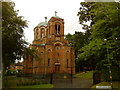
Serbian Orthodox Church of the Holy Prince Lazar
Image: © Andrew Abbott
Taken: 17 Jul 2010
0.15 miles