IMAGES TAKEN NEAR TO
Beaumont Road, BIRMINGHAM, B30 1NU
Introduction
This page details the photographs taken nearby to Beaumont Road, B30 1NU by members of the Geograph project.
The Geograph project started in 2005 with the aim of publishing, organising and preserving representative images for every square kilometre of Great Britain, Ireland and the Isle of Man.

There are currently over 7.5m images from over14,400 individuals and you can help contribute to the project by visiting https://www.geograph.org.uk
Image Map
Images are licensed for reuse under creativecommons.org/licenses/by-sa/2.0
Notes
- Clicking on the map will re-center to the selected point.
- The higher the marker number, the further away the image location is from the centre of the postcode.
Image Listing (28 Images Found)
Images are licensed for reuse under creativecommons.org/licenses/by-sa/2.0
Image
Details
Distance
1
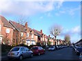
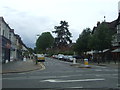
Mary Vale Rd
Mary Vale Rd is the eastern extension of Heath Rd and runs all the way east to the Pershore Rd in Stirchley.
Image: © Nigel Mykura
Taken: 8 Jan 2011
0.07 miles
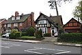
2
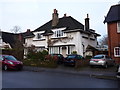
270 & 272 Mary Vale Road, Bournville
A pair of 'Arts & Crafts' semis, dating from around 1905 by the architect W. Alexander Harvey. They were collectively Grade II listed https://britishlistedbuildings.co.uk/101076260-270-and-272-mary-vale-road-b30-bournville-ward#.Xi3Kx2j7TIU & https://historicengland.org.uk/listing/the-list/list-entry/1076260 in 1982.
Image: © Richard Law
Taken: 16 Dec 2019
0.09 miles
3
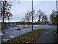
Roundabout on Selly Oak Road
Heath Road to the left, with Mary Vale Road to the right.
Image: © Richard Law
Taken: 16 Dec 2019
0.09 miles
4
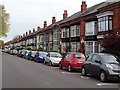
Mary Vale Road
The houses on this road called Mary Vale Road in Bournville all have large box bay windows. These houses are known as the 'Alphabet Houses' as they all have names on the lintel over the front door. Though most are in alphabetic order some are out of order. These houses are just outside the Cadbury Village Trust area at Bournville and we built by a private property developer.
Image: © Philip Halling
Taken: 23 Oct 2018
0.12 miles
5
Mary Vale Road, Bournville
Looking south west.
Image: © JThomas
Taken: 22 Jul 2017
0.12 miles
6
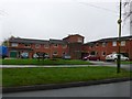
Rowheath House Bournville
This apartment block is on the south side of Rowheath Playing Fields in Heath Rd, just west of Selly Oak Rd. Rowheath House is sheltered housing and supported housing for older people based in Birmingham, run by Bournville Village Trust.
Image: © Nigel Mykura
Taken: 19 Feb 2011
0.13 miles
7
Brick Pillar with cut Benchmark
The pillar is on the northwest corner of the grounds of Kings Norton Girls' School.
Image: © Paul Collins
Taken: 7 Jan 2023
0.14 miles
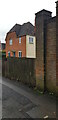
8
Houses on Bournville Lane
Part of Bournville Village Trust
Image: © Andrew Abbott
Taken: 29 Apr 2018
0.14 miles
9
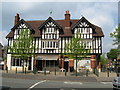
First shops in Bournville? - Birmingham
This block of Tudor style shops, located at the junction of Mary Vale Road and Linden Road, are thought to be the first shops built in Bournville, making their appearance in 1897. Time photo taken 11.57 am BST (British Summer Time).
Image: © Martin Richard Phelan
Taken: 17 Apr 2011
0.14 miles
10
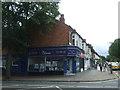
Estate agents on Mary Vale Road, Bournville
Image: © JThomas
Taken: 22 Jul 2017
0.15 miles