IMAGES TAKEN NEAR TO
Selly Oak Road, BIRMINGHAM, B30 1HN
Introduction
This page details the photographs taken nearby to Selly Oak Road, B30 1HN by members of the Geograph project.
The Geograph project started in 2005 with the aim of publishing, organising and preserving representative images for every square kilometre of Great Britain, Ireland and the Isle of Man.

There are currently over 7.5m images from over14,400 individuals and you can help contribute to the project by visiting https://www.geograph.org.uk
Image Map
Images are licensed for reuse under creativecommons.org/licenses/by-sa/2.0
Notes
- Clicking on the map will re-center to the selected point.
- The higher the marker number, the further away the image location is from the centre of the postcode.
Image Listing (20 Images Found)
Images are licensed for reuse under creativecommons.org/licenses/by-sa/2.0
Image
Details
Distance
1
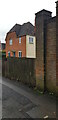
Brick Pillar with cut Benchmark
The pillar is on the northwest corner of the grounds of Kings Norton Girls' School.
Image: © Paul Collins
Taken: 7 Jan 2023
0.02 miles
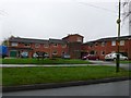
2
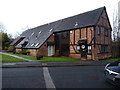
Rowheath Farm Barn
Long since converted for residential use, but dating in the main back to the 18th, or possibly late 17th, century. It was Grade II listed https://britishlistedbuildings.co.uk/101220952-rowheath-farm-barn-bournville-ward#.Xi6WTGj7RPY & https://historicengland.org.uk/listing/the-list/list-entry/1220952 in 1982.
Image: © Richard Law
Taken: 16 Dec 2019
0.13 miles
3
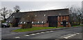
Rowheath Farm Barn
The barn, now converted into dwellings, is grade II listed and probably 18th century in date.
Image: © Paul Collins
Taken: 7 Jan 2023
0.14 miles
5
Rowheath House Bournville
This apartment block is on the south side of Rowheath Playing Fields in Heath Rd, just west of Selly Oak Rd. Rowheath House is sheltered housing and supported housing for older people based in Birmingham, run by Bournville Village Trust.
Image: © Nigel Mykura
Taken: 19 Feb 2011
0.15 miles
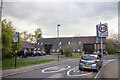
6
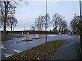
Roundabout on Selly Oak Road
Heath Road to the left, with Mary Vale Road to the right.
Image: © Richard Law
Taken: 16 Dec 2019
0.18 miles
8
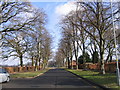
Cotteridge - Heath Road
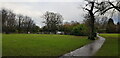
Looking towards the cross-roads with Selly Oak Road. The Rowheath playing fields on the left.
Image: © Roy Hughes
Taken: 20 Feb 2009
0.19 miles
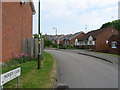
10
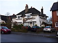
270 & 272 Mary Vale Road, Bournville
A pair of 'Arts & Crafts' semis, dating from around 1905 by the architect W. Alexander Harvey. They were collectively Grade II listed https://britishlistedbuildings.co.uk/101076260-270-and-272-mary-vale-road-b30-bournville-ward#.Xi3Kx2j7TIU & https://historicengland.org.uk/listing/the-list/list-entry/1076260 in 1982.
Image: © Richard Law
Taken: 16 Dec 2019
0.19 miles