IMAGES TAKEN NEAR TO
Warwards Lane, BIRMINGHAM, B29 7RE
Introduction
This page details the photographs taken nearby to Warwards Lane, B29 7RE by members of the Geograph project.
The Geograph project started in 2005 with the aim of publishing, organising and preserving representative images for every square kilometre of Great Britain, Ireland and the Isle of Man.

There are currently over 7.5m images from over14,400 individuals and you can help contribute to the project by visiting https://www.geograph.org.uk
Image Map (17 Images)


Leaflet Map data © OpenStreetMap
Images are licensed for reuse under creativecommons.org/licenses/by-sa/2.0
Notes
- Clicking on the map will re-center to the selected point.
- The higher the marker number, the further away the image location is from the centre of the postcode.
Image Listing (17 Images Found)
Images are licensed for reuse under creativecommons.org/licenses/by-sa/2.0
Image
Details
Distance
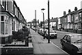
2
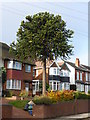
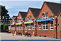
105 Warwards Lane
Araucaria araucana
Image: © araucaria araucana
Taken: 16 Oct 2014
0.12 miles
6
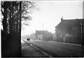
Raddlebarn Road, Selly Park
Taken near the junction with Dawlish Road.
Image: © Chris Denny
Taken: Unknown
0.20 miles
7
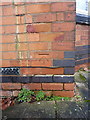
OS benchmark - Selly Park, 40 Umberslade Road
OS cutmark on the wall of 40 Umberslade Road; originally levelled in 1965 at 143.241m above Ordnance Datum Newlyn.
Image: © Richard Law
Taken: 16 Dec 2019
0.21 miles
8
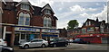
Smallbone Car Sales, Raddlebarn Road
Smallbone are a long-established car sales business.
Image: © Paul Collins
Taken: 5 May 2023
0.22 miles
9
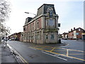
The New Dogpool Hotel
That's the description and signage on this narrow frontage, although there's also a hanging sign on the wall describing it as The Hibernian (including a picture of a Scots Guardsman, piping in full regalia). A quick investigation on the wonderful internet rather suggests that the former Hibernian became the Dogpool, and was an entertainment venue for a while with live bands. The gig list rather dried up a few years ago, around late 2009, so it may well now be closed. (If the foregoing is incorrect, I am more than happy to update this description straight away.)
Image: © Richard Law
Taken: 16 Dec 2019
0.23 miles
10
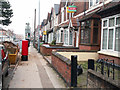
Pillar box and former post office, Raddlebarn Road
The letter box is in front of the former post office. around thirty sub post offices in the Birmingham, area were closed down in the mid noughties. Work was ongoing to convert the branch into a house, most likely to be let to students at Birmingham University.
Image: © Phil Champion
Taken: 22 Jan 2006
0.24 miles