IMAGES TAKEN NEAR TO
Warwards Lane, BIRMINGHAM, B29 7RB
Introduction
This page details the photographs taken nearby to Warwards Lane, B29 7RB by members of the Geograph project.
The Geograph project started in 2005 with the aim of publishing, organising and preserving representative images for every square kilometre of Great Britain, Ireland and the Isle of Man.

There are currently over 7.5m images from over14,400 individuals and you can help contribute to the project by visiting https://www.geograph.org.uk
Image Map
Images are licensed for reuse under creativecommons.org/licenses/by-sa/2.0
Notes
- Clicking on the map will re-center to the selected point.
- The higher the marker number, the further away the image location is from the centre of the postcode.
Image Listing (35 Images Found)
Images are licensed for reuse under creativecommons.org/licenses/by-sa/2.0
Image
Details
Distance
1
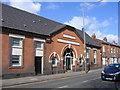
Cox, Wilcox & Co. Ltd - Frontage Saved by Developers
The original frontage has been preserved by the developers and the new estate built to the rear. See image of houses.
Image: © Roy Hughes
Taken: 9 Mar 2009
0.05 miles
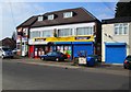
2
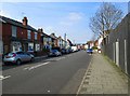
Warwards Lane, Stirchley, Birmingham
A long mainly residential road which ends at its junction with Raddlebarn Road. Before reaching that point it runs alongside Selly Park.
Image: © P L Chadwick
Taken: 8 Apr 2015
0.05 miles
3
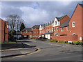
Ten Acres Mews, Off Pershore Road Birmingham
This new development lies behind the original frontage of Cox, Wilcox & Co. Ltd Image off the Pershore Road, A441, Ten Acres, Stirchley, Birmingham.
Image: © Roy Hughes
Taken: 9 Mar 2009
0.06 miles
4
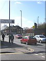
Welcome to Stirchley Village - Pershore Road A441
Approaching Stirchley, Birmingham along the A441 Pershore Road heading out of the City.
Image: © Roy Hughes
Taken: 9 Mar 2009
0.09 miles
5
Premier Kwik Stop Convenience Store, 16 Ribblesdale Road, Stirchley, Birmingham
This store is a member of a leading group of independent convenience stores which trade under the Premier brand. The brand is owned by the wholesalers Booker Cash & Carry Ltd who provide stock and support.
Image: © P L Chadwick
Taken: 8 Apr 2015
0.09 miles
6
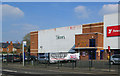
PSL Bowling, Pershore Road, Stirchley, Birmingham
Although still branded 1st Bowling, this ten pin bowling centre is now a branch of PSL Bowling. It also has American Pool tables, arcades and games, and eating and other facilities. Outside is a bus stop.
Image: © P L Chadwick
Taken: 8 Apr 2015
0.09 miles
7
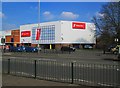
Fitness First, 1 Pershore Road South, Stirchley, Birmingham
A large gym which is a branch of a nationwide chain.
Image: © P L Chadwick
Taken: 8 Apr 2015
0.11 miles
8
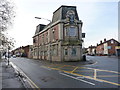
The New Dogpool Hotel
That's the description and signage on this narrow frontage, although there's also a hanging sign on the wall describing it as The Hibernian (including a picture of a Scots Guardsman, piping in full regalia). A quick investigation on the wonderful internet rather suggests that the former Hibernian became the Dogpool, and was an entertainment venue for a while with live bands. The gig list rather dried up a few years ago, around late 2009, so it may well now be closed. (If the foregoing is incorrect, I am more than happy to update this description straight away.)
Image: © Richard Law
Taken: 16 Dec 2019
0.12 miles
9
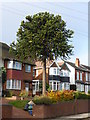
105 Warwards Lane
Araucaria araucana
Image: © araucaria araucana
Taken: 16 Oct 2014
0.12 miles
10
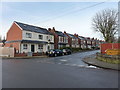
Gristhorpe Road from Ribblesdale Road, Stirchley
Turn of the 20th century housing in the Stirchley area of Birmingham.
Image: © Richard Law
Taken: 16 Dec 2019
0.15 miles