IMAGES TAKEN NEAR TO
St. Edwards Road, BIRMINGHAM, B29 7DJ
Introduction
This page details the photographs taken nearby to St. Edwards Road, B29 7DJ by members of the Geograph project.
The Geograph project started in 2005 with the aim of publishing, organising and preserving representative images for every square kilometre of Great Britain, Ireland and the Isle of Man.

There are currently over 7.5m images from over14,400 individuals and you can help contribute to the project by visiting https://www.geograph.org.uk
Image Map
Images are licensed for reuse under creativecommons.org/licenses/by-sa/2.0
Notes
- Clicking on the map will re-center to the selected point.
- The higher the marker number, the further away the image location is from the centre of the postcode.
Image Listing (125 Images Found)
Images are licensed for reuse under creativecommons.org/licenses/by-sa/2.0
Image
Details
Distance
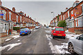
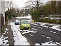
1
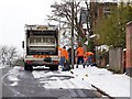
Rubbish collection day in St Edward's Road
Looking ENE up St. Edward's Road from Selly Hill Road.
The weather in late March was unseasonably cold and snowy.
Image: © David P Howard
Taken: 27 Mar 2013
0.01 miles
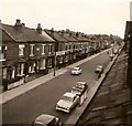
2
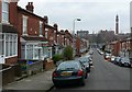
Alton Rd Selly Oak
View north along this street of victorian terraced houses towards Birmingham University which can be seen in the distance. Nearly all the houses are occupied by students.
Image: © Nigel Mykura
Taken: 28 Feb 2009
0.03 miles
3
Rookery Road, looking towards the University of Birmingham
Image: © David Martin
Taken: 18 Oct 2014
0.03 miles
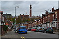
5
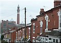
Alton Rd Selly Oak
View across the roofs of the terraced houses towards the University of Birmingham clock tower known affectionately as Joe after Joseph Chamberlain. Next to it is the University main Hall.
Image: © Nigel Mykura
Taken: 28 Feb 2009
0.04 miles
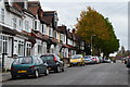
6
Alton Road, Selly Oak
Looking SSE up Alton Road.
The photographer is standing on the northern edge of the grid square.
Given the close proximity to the University, the roads in this area are prime student accommodation territory. The number of To Let signs in the road indicate a regular turn over of tenants.
The weather was unseasonably cold and snowy for late March.
Image: © David P Howard
Taken: 27 Mar 2013
0.05 miles
7
Dawlish Road, 1964
This was considered a busy road then, with its bus route, school and many small shops - yet it looks deserted here. I took this from my bedroom window with an ancient box camera I inherited from my grandfather.
Image: © Chris Denny
Taken: Unknown
0.08 miles
8
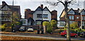
Turreted Semis on Bournbrook Road
This pair of semi-detached houses are unique in the road and, as far as I know, in the area in possessing turrets.
Image: © Paul Collins
Taken: 28 Oct 2022
0.08 miles
9
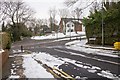
St Edward's Road
Looking east down St. Edward's Road toward the junction with Bournbrook Road.
The photographer is standing on the western edge of the grid square.
The weather in late March was unseasonably cold and snowy.
Image: © David P Howard
Taken: 27 Mar 2013
0.08 miles
10
St Edward's Road
Looking east down St. Edward's Road toward the junction with Bournbrook Road.
The weather in late March was unseasonably cold and snowy.
Image: © David P Howard
Taken: 27 Mar 2013
0.09 miles