IMAGES TAKEN NEAR TO
Reservoir Road, BIRMINGHAM, B29 6TE
Introduction
This page details the photographs taken nearby to Reservoir Road, B29 6TE by members of the Geograph project.
The Geograph project started in 2005 with the aim of publishing, organising and preserving representative images for every square kilometre of Great Britain, Ireland and the Isle of Man.

There are currently over 7.5m images from over14,400 individuals and you can help contribute to the project by visiting https://www.geograph.org.uk
Image Map
Images are licensed for reuse under creativecommons.org/licenses/by-sa/2.0
Notes
- Clicking on the map will re-center to the selected point.
- The higher the marker number, the further away the image location is from the centre of the postcode.
Image Listing (4 Images Found)
Images are licensed for reuse under creativecommons.org/licenses/by-sa/2.0
Image
Details
Distance
1
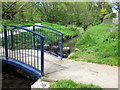
Bourn Brook Footbridge
The Bourne Brook emerges at Watery Lane, Woodgate and runs through Bartley Green, the edge of Harborne and Selly Oak before joining the River Rea near Cannon Hill Park.
Image: © Roy Hughes
Taken: 16 May 2012
0.13 miles
2
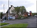
The Hilly Fields
A Pub on Quinton Road.
Image: © Gordon Griffiths
Taken: 9 May 2010
0.14 miles
3
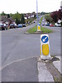
Quinton Road
The view down the road from the junction with Mill Farm Road.
Image: © Gordon Griffiths
Taken: 9 May 2010
0.17 miles
4
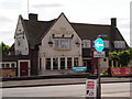
Hillyfields at Harborne
On Quinton road going towards Queen Elizabeth Hospital at Harborne.
Image: © paul phipps
Taken: 19 May 2011
0.19 miles