IMAGES TAKEN NEAR TO
Durley Dean Road, BIRMINGHAM, B29 6RX
Introduction
This page details the photographs taken nearby to Durley Dean Road, B29 6RX by members of the Geograph project.
The Geograph project started in 2005 with the aim of publishing, organising and preserving representative images for every square kilometre of Great Britain, Ireland and the Isle of Man.

There are currently over 7.5m images from over14,400 individuals and you can help contribute to the project by visiting https://www.geograph.org.uk
Image Map
Images are licensed for reuse under creativecommons.org/licenses/by-sa/2.0
Notes
- Clicking on the map will re-center to the selected point.
- The higher the marker number, the further away the image location is from the centre of the postcode.
Image Listing (4 Images Found)
Images are licensed for reuse under creativecommons.org/licenses/by-sa/2.0
Image
Details
Distance
1
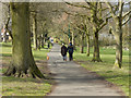
Selly Oak Park
Two dog walkers make their way towards the Corisande Road gate.
Image: © Stephen McKay
Taken: 3 Apr 2019
0.17 miles
2
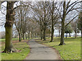
Selly Oak Park
The path snakes away towards Harborne Lane.
Image: © Stephen McKay
Taken: 3 Apr 2019
0.21 miles
3
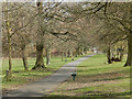
Selly Oak Park
The path leads down towards the bridge over the old Lapal Canal.
Image: © Stephen McKay
Taken: 3 Apr 2019
0.24 miles
4
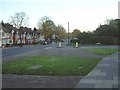
Jcn Gibbins Rd and Lodge Hill Road
Just a few yards past this junction is Selly Oak Park.
Image: © Chris Hoare
Taken: 31 Oct 2006
0.24 miles