IMAGES TAKEN NEAR TO
Strathdene Road, BIRMINGHAM, B29 6QB
Introduction
This page details the photographs taken nearby to Strathdene Road, B29 6QB by members of the Geograph project.
The Geograph project started in 2005 with the aim of publishing, organising and preserving representative images for every square kilometre of Great Britain, Ireland and the Isle of Man.

There are currently over 7.5m images from over14,400 individuals and you can help contribute to the project by visiting https://www.geograph.org.uk
Image Map
Images are licensed for reuse under creativecommons.org/licenses/by-sa/2.0
Notes
- Clicking on the map will re-center to the selected point.
- The higher the marker number, the further away the image location is from the centre of the postcode.
Image Listing (5 Images Found)
Images are licensed for reuse under creativecommons.org/licenses/by-sa/2.0
Image
Details
Distance
1
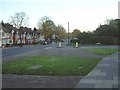
Jcn Gibbins Rd and Lodge Hill Road
Just a few yards past this junction is Selly Oak Park.
Image: © Chris Hoare
Taken: 31 Oct 2006
0.13 miles
2
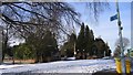
Selly Oak Crematorium Entrance
At the junction of Weoley Park Road and Weoley Avenue.
Image: © Roy Hughes
Taken: 4 Feb 2009
0.17 miles
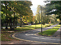
4
Lodge Hill Cemetery
Opened in 1895 by King's Norton Rural District Council, it was absorbed by Birmingham when the city extended its boundaries in 1911. It has an area of over 24 hectares. A crematorium was built here in the 1930s [source: Birmingham City Council].
Image: © Robin Stott
Taken: 9 Apr 2009
0.25 miles
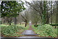
5
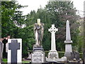
Lodge Hill Cemetery
Opened in 1895. The oldest parts show a rich variety of memorials, imagery and trees.
Image: © Robin Stott
Taken: 9 Apr 2009
0.25 miles