IMAGES TAKEN NEAR TO
Tiverton Road, BIRMINGHAM, B29 6BT
Introduction
This page details the photographs taken nearby to Tiverton Road, B29 6BT by members of the Geograph project.
The Geograph project started in 2005 with the aim of publishing, organising and preserving representative images for every square kilometre of Great Britain, Ireland and the Isle of Man.

There are currently over 7.5m images from over14,400 individuals and you can help contribute to the project by visiting https://www.geograph.org.uk
Image Map
Images are licensed for reuse under creativecommons.org/licenses/by-sa/2.0
Notes
- Clicking on the map will re-center to the selected point.
- The higher the marker number, the further away the image location is from the centre of the postcode.
Image Listing (168 Images Found)
Images are licensed for reuse under creativecommons.org/licenses/by-sa/2.0
Image
Details
Distance
1
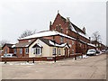
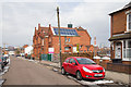
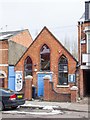
Selly Oak Elim Church, Exeter Road
On the corner of Exeter Road and Tiverton Road.
Selly Oak Elim Church was founded in 1936 (2006 was the church's 70th anniversary), born out of Birmingham's Pentecostal Revival of the 1930s. The church first met in people's homes and then in the Institute building on Bristol Road before moving to a permanent site in Alton Road. In 1983, two buildings later, the church were outgrowing their premises and arranged to swap buildings with St. Wulstan's. Today, they meet at Elim Church Centre on Exeter Road (2006 was the building's 100th anniversary and the church's 70th anniversary). http://www.sellyelim.org/index.php/aboutus/about-us
Image: © David P Howard
Taken: 27 Mar 2013
0.05 miles
2
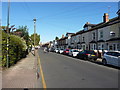
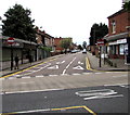
Dawlish Road, Bournbrook
There's a very definite 'Devonshire' theme to the road names in this area - nearby are Teignmouth, Exeter and Tiverton Roads.
Image: © Richard Law
Taken: 17 Oct 2019
0.06 miles
3
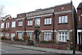
Old Medical building Selly Oak, Birmingham
This building in Exeter Rd Selly Oak at the junction with Hubert Rd and has been converted to apartments. The only clue to its former use is carved and gilded lettering above the right hand window that says "Patients Entrance". This is almost certainly the former Head Injuries Unit (presumably connected with Selly Oak Hospital which is only a short distance away in the same square) which was converted to flats in c.1994. Thanks to Keith Edkins for the information.
Image: © Nigel Mykura
Taken: 12 Nov 2008
0.07 miles
4
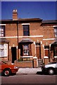
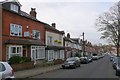
Exeter Road 1990
A typical terraced house of the area, many of which are let to students.
Image: © Ruth Riddle
Taken: Unknown
0.08 miles
5
Tiverton Primary School
The school in Tiverton Road. http://www.tiverton.bham.sch.uk/
The weather in late March was unseasonably cold and snowy.
Image: © David P Howard
Taken: 27 Mar 2013
0.08 miles
6
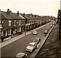
Dawlish Road, 1964
This was considered a busy road then, with its bus route, school and many small shops - yet it looks deserted here. I took this from my bedroom window with an ancient box camera I inherited from my grandfather.
Image: © Chris Denny
Taken: Unknown
0.10 miles
7
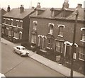
Dawlish Rd Selly Oak Birmingham
A long road of victorian terraced houses off the Bristol Rd. Close to the university, most of the houses are rented by students. In the distance can be seen the university and the new medical School Hospital being built.
Image: © Nigel Mykura
Taken: 12 Nov 2008
0.10 miles
8
Dawlish Road, 1964
Taken at the same time as Image, the clock tower of the university can just be seen above the roof of the houses on the left. For the five years in the early sixties I lived in the street every quarter hour was loudly punctuated by the clock.
Image: © Chris Denny
Taken: Unknown
0.14 miles
9
City @ Tiv Road
The Tiverton Road premises of the City Church, Birmingham. http://www.city-church.org.uk/
The weather in late March was unseasonably cold and snowy.
Image: © David P Howard
Taken: 27 Mar 2013
0.14 miles
10
Hubert Road, Selly Oak, Birmingham
No Entry signs face Bristol Road.
Image: © Jaggery
Taken: 17 Sep 2016
0.14 miles