IMAGES TAKEN NEAR TO
Shenley Lane, BIRMINGHAM, B29 4HZ
Introduction
This page details the photographs taken nearby to Shenley Lane, B29 4HZ by members of the Geograph project.
The Geograph project started in 2005 with the aim of publishing, organising and preserving representative images for every square kilometre of Great Britain, Ireland and the Isle of Man.

There are currently over 7.5m images from over14,400 individuals and you can help contribute to the project by visiting https://www.geograph.org.uk
Image Map
Images are licensed for reuse under creativecommons.org/licenses/by-sa/2.0
Notes
- Clicking on the map will re-center to the selected point.
- The higher the marker number, the further away the image location is from the centre of the postcode.
Image Listing (27 Images Found)
Images are licensed for reuse under creativecommons.org/licenses/by-sa/2.0
Image
Details
Distance
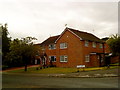
1
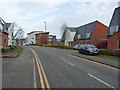
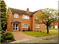
New-build housing on Black Haynes Road, Northfield
Image: © Richard Law
Taken: 8 Jan 2020
0.06 miles
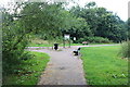
2
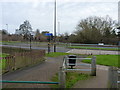
The Merritt's Brook Greenway at Shenley Lane
All sorts of street furniture and barriers to ease the crossing of the walkway and cycle route over the B4121 dual carriageway.
Image: © Richard Law
Taken: 8 Jan 2020
0.09 miles
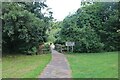
4
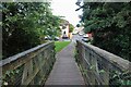
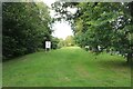
Bridge across Griffin's Brook, Northfield
In Manor Farm Park
Image: © David Howard
Taken: 8 Aug 2021
0.11 miles
5
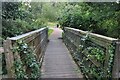
Bridge across Griffin's Brook, Northfield
Image: © David Howard
Taken: 8 Aug 2021
0.12 miles
8
Bridge across Griffin's Brook, Northfield
In Manor Park Farm
Image: © David Howard
Taken: 8 Aug 2021
0.12 miles