IMAGES TAKEN NEAR TO
Arkley Road, BIRMINGHAM, B28 9PJ
Introduction
This page details the photographs taken nearby to Arkley Road, B28 9PJ by members of the Geograph project.
The Geograph project started in 2005 with the aim of publishing, organising and preserving representative images for every square kilometre of Great Britain, Ireland and the Isle of Man.

There are currently over 7.5m images from over14,400 individuals and you can help contribute to the project by visiting https://www.geograph.org.uk
Image Map
Images are licensed for reuse under creativecommons.org/licenses/by-sa/2.0
Notes
- Clicking on the map will re-center to the selected point.
- The higher the marker number, the further away the image location is from the centre of the postcode.
Image Listing (8 Images Found)
Images are licensed for reuse under creativecommons.org/licenses/by-sa/2.0
Image
Details
Distance
1
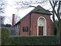
Hall Green Pentecostal Church
Situated on Cresswell Road.
Image: © David Stowell
Taken: 25 Dec 2005
0.15 miles
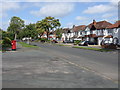
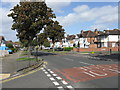
4
Westhay Road, Hall Green
Off Redstone Farm Road.
Image: © Richard Vince
Taken: 8 Jun 2019
0.19 miles
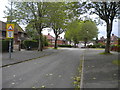
6
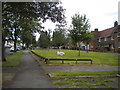
Wide verge along Redstone Farm Road, Hall Green
Image: © Richard Vince
Taken: 8 Jun 2019
0.22 miles
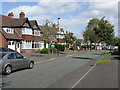
7
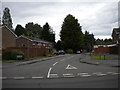
Westley Close, Shirley
Off Redstone Farm Road, which forms the boundary between Birmingham and Solihull at this point; Westley Close is in the latter.
Image: © Richard Vince
Taken: 8 Jun 2019
0.24 miles
8
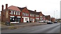
Shopping Parade in Redstone Farm Road
This parade could not be described as thriving. It appears to consist of a hairdressers (under new management), a vacant unit, a children's nursery and two units converted to residential occupation.
Image: © Paul Collins
Taken: 8 Jan 2018
0.25 miles