IMAGES TAKEN NEAR TO
Stratford Road, BIRMINGHAM, B28 9ET
Introduction
This page details the photographs taken nearby to Stratford Road, B28 9ET by members of the Geograph project.
The Geograph project started in 2005 with the aim of publishing, organising and preserving representative images for every square kilometre of Great Britain, Ireland and the Isle of Man.

There are currently over 7.5m images from over14,400 individuals and you can help contribute to the project by visiting https://www.geograph.org.uk
Image Map
Images are licensed for reuse under creativecommons.org/licenses/by-sa/2.0
Notes
- Clicking on the map will re-center to the selected point.
- The higher the marker number, the further away the image location is from the centre of the postcode.
Image Listing (9 Images Found)
Images are licensed for reuse under creativecommons.org/licenses/by-sa/2.0
Image
Details
Distance
1
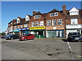
Shops and businesses by the Stratford Road island
The vacant office in the middle of the picture was, until recently, an estate agency.
Image: © Richard Law
Taken: 18 Apr 2018
0.07 miles
2
Stratford Road island
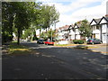
Built on the A34 as it runs NW/SE past Yardley Wood, the roundabout provides access to Robin Hood Lane, Solihull Lane, Baldwins Lane and Shirley Road.
Image: © Richard Law
Taken: 18 Apr 2018
0.10 miles
3
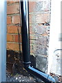
OS benchmark - Hall Green, 95 Solihull Lane
An OS cutmark on the side wall of the house, which was levelled in 1965 at 147.710m above Ordnance Datum Newlyn.
Image: © Richard Law
Taken: 18 Apr 2018
0.15 miles
4
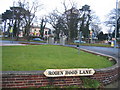
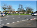
Robin Hood Island
At the junction of Robin Hood Lane with the Stratford Road. Robin Hood "lane" is a dual carriageway!
Image: © David Stowell
Taken: 25 Dec 2005
0.15 miles
5
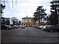
The Robin Hood
Now a large family eatery adjacent to the Robin Hood Island on the Stratford Road.
Image: © David Stowell
Taken: 25 Dec 2005
0.16 miles

7
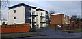
Loxley Court, Baldwins Lane
To quote the developer's sign, Loxley Court is "a bespoke development of thirteen luxury 2 bedroom apartments". There are two blocks which replace an older semi-detached building, one side of which was latterly a vets.
Image: © Paul Collins
Taken: 3 Feb 2021
0.18 miles
8
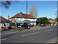
Small parade of shops on Solihull Lane
Solihull Lane here turns into Streetsbrook Road heading east, at the junction with Redstone Farm Road. the shops are a beautician (hair, nails, tanning etc), a hair salon, and a local convenience store.
Image: © Richard Law
Taken: 18 Apr 2018
0.21 miles