IMAGES TAKEN NEAR TO
Dunsmore Road, BIRMINGHAM, B28 8EA
Introduction
This page details the photographs taken nearby to Dunsmore Road, B28 8EA by members of the Geograph project.
The Geograph project started in 2005 with the aim of publishing, organising and preserving representative images for every square kilometre of Great Britain, Ireland and the Isle of Man.

There are currently over 7.5m images from over14,400 individuals and you can help contribute to the project by visiting https://www.geograph.org.uk
Image Map
Images are licensed for reuse under creativecommons.org/licenses/by-sa/2.0
Notes
- Clicking on the map will re-center to the selected point.
- The higher the marker number, the further away the image location is from the centre of the postcode.
Image Listing (9 Images Found)
Images are licensed for reuse under creativecommons.org/licenses/by-sa/2.0
Image
Details
Distance
3

The College Arms
Landmark pub on the corner of Stratford Road and Shaftmoor Lane.
Image: © Richard Law
Taken: 12 Sep 2018
0.18 miles
4
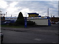
Hall Green Stadium, York Road, Birmingham
Greyhound Racing stadium
Image: © peter lloyd
Taken: 23 Dec 2005
0.19 miles
5
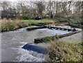
Millstream Way along the River Cole
Part of the Shire Country Park.
Image: © Mat Fascione
Taken: 14 Dec 2020
0.20 miles
6
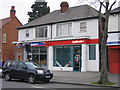
Site of Midland Bank / HSBC Hall Green 40-11-11
I worked for Midland Bank HSBC for 32 years and spent all but the last two in Birmingham Branches. I am photographing all the branches, or what's left of them, as they were when I joined Midland Bank in 1963. The branches all start with the sorting code 40-11.
This was the Hall Green branch at 1146 Stratford Road It later became a sub-office to Kings Heath Branch before closing and now being used by a bookmakers. The sorting code was 40-11-11.
Image: © Roy Hughes
Taken: 30 Dec 2008
0.22 miles
7
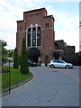
The (former) Sparkhill United Church
A rather fine Romanesque-style building, dating from the early 1930s, and Grade II listed https://britishlistedbuildings.co.uk/101096067-sparkhill-united-church-including-church-rooms-to-rear-springfield-ward#.W9lfFUv7RPY in 2003. The church was designed by the local architect W H Bidlake, and the listing includes the Church Rooms building to the rear of here. It's now a very striking Indian restaurant.
Image: © Richard Law
Taken: 12 Sep 2018
0.23 miles
8
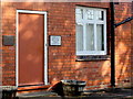
Side Door to Ashley House
This red brick building was once a residential house but it is now the premises of an insurance company. Although it is the side door and faces onto Green Rd, it is numbered 1143 Stratford Rd.
The brickwork in the wall is a good example of flemish stretcher bond with three rows of stretchers followed by a single row of alternating headers and stretchers, followed by another three rows of stretchers
Image: © Nigel Mykura
Taken: 1 Sep 2017
0.23 miles
9
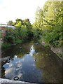
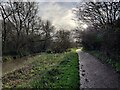
River Cole, looking north, in Springfield
The Cole here is a bit of a dump, frankly - apparently it's fine to lob old tyres and the like into it, as clearly it generates enough flow to wash them away. Or perhaps not.
Image: © Richard Law
Taken: 12 Sep 2018
0.24 miles