IMAGES TAKEN NEAR TO
Bach Mill Drive, BIRMINGHAM, B28 0XN
Introduction
This page details the photographs taken nearby to Bach Mill Drive, B28 0XN by members of the Geograph project.
The Geograph project started in 2005 with the aim of publishing, organising and preserving representative images for every square kilometre of Great Britain, Ireland and the Isle of Man.

There are currently over 7.5m images from over14,400 individuals and you can help contribute to the project by visiting https://www.geograph.org.uk
Image Map
Images are licensed for reuse under creativecommons.org/licenses/by-sa/2.0
Notes
- Clicking on the map will re-center to the selected point.
- The higher the marker number, the further away the image location is from the centre of the postcode.
Image Listing (26 Images Found)
Images are licensed for reuse under creativecommons.org/licenses/by-sa/2.0
Image
Details
Distance
1
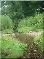
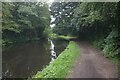
Yardley Wood Brook, Priory Fields nature reserve
Birmingham on the left, Solihull on the right.
Yardley Wood Brook rises near Prince of Wales Lane at Gorleston Road.
It is nearly a mile long, but culverted for half its length and runs under the Stratford-on-Avon canal.
It marks the Birmingham/Solihull boundary and is open through this surviving strip of Yardley Wood Common.
It runs into Priory Mill Pool then on to the Cole.
Image: © planetearthisblue
Taken: 10 Jul 2007
0.10 miles
2
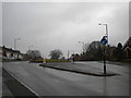
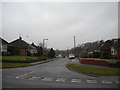
South end of dual carriageway, Priory Road, Yardley Wood
The gap in the central reservation here has long been used for turning buses arriving from Birmingham city centre via the dual carriageway section of Priory Road. Route 38 originally terminated here; in the 1980s it was sensibly combined with the very similar 13 to form the 12, a single route for the eastern part of Yardley Wood. In the early 2000s (if memory serves), the 12 was extended to Shirley Station; a few years later it was further extended to Solihull and renumbered 3, but has since been cut back to terminate here once more.
Image: © Richard Vince
Taken: 10 Mar 2018
0.11 miles
4
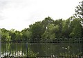
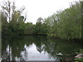
Lake on Priory Road, Shirley
Don't blink or you'll miss it. Small lake, below Stratford upon Avon Canal, but above River Cole to east, this is habitat for much wildlife
Image: © Michael Westley
Taken: 23 Jun 2011
0.14 miles
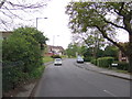
5
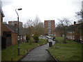
Millside, Yardley Wood
A footpath off Priory Road, just inside the Birmingham city boundary.
Image: © Richard Vince
Taken: 10 Mar 2018
0.14 miles
10
North end of Coton Grove, Hasluck's Green
Seen from Windmill Road.
Image: © Richard Vince
Taken: 10 Mar 2018
0.18 miles