IMAGES TAKEN NEAR TO
Tixall Road, BIRMINGHAM, B28 0RY
Introduction
This page details the photographs taken nearby to Tixall Road, B28 0RY by members of the Geograph project.
The Geograph project started in 2005 with the aim of publishing, organising and preserving representative images for every square kilometre of Great Britain, Ireland and the Isle of Man.

There are currently over 7.5m images from over14,400 individuals and you can help contribute to the project by visiting https://www.geograph.org.uk
Image Map
Images are licensed for reuse under creativecommons.org/licenses/by-sa/2.0
Notes
- Clicking on the map will re-center to the selected point.
- The higher the marker number, the further away the image location is from the centre of the postcode.
Image Listing (38 Images Found)
Images are licensed for reuse under creativecommons.org/licenses/by-sa/2.0
Image
Details
Distance
1
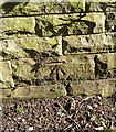
OS benchmark - Yardley Wood, wall on Highfield Road
An OS cutmark on the wall outside nos 276 & 278; originally levelled, probably in 1965, at 138.34m above Ordnance Datum Newlyn.
Image: © Richard Law
Taken: 18 Apr 2018
0.03 miles
3
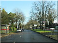
Highfield Road railway bridge
An assortment of street furniture clutters the view slightly in this shot of the bridge, where Highfield Road crosses the Tyseley Junction to Henley-in-Arden line.
Image: © Richard Law
Taken: 18 Apr 2018
0.08 miles
4
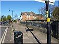
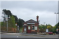
Yardley Wood Station
Station ticket office and entrance for trains to Birmingham (entrance for trains to Shirley is just off to the left). Not the busiest of stations on the line, and at the time there was much less traffic on the road outside (like the cars).
Image: © Michael Westley
Taken: Unknown
0.09 miles
5
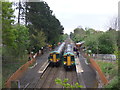
Yardley Wood Railway Station
Cross over of London Midland Class 172's, Nos 172342 and 172214.
View from the bridge on Highfield Road.
Image: © JThomas
Taken: 6 May 2017
0.09 miles
6
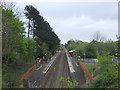
Yardley Wood Railway Station
View from the bridge on Highfield Road.
Image: © JThomas
Taken: 6 May 2017
0.09 miles
7
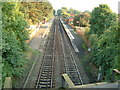
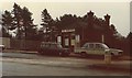
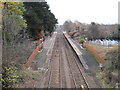
Yardley Wood Railway Station
This is a view of the tracks and platform looking south from Highfield Road, Hall Green
Image: © Darius Khan
Taken: 25 Sep 2001
0.09 miles
8
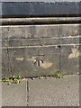
OS benchmark - Yardley Wood, railway station bridge
An OS cutmark low on the parapet wall of the bridge carrying Highfield Road over the railway, just north of the station. It was originally levelled, probably in 1965, at 134.34m above Ordnance Datum Newlyn.
Image: © Richard Law
Taken: 18 Apr 2018
0.09 miles
10
Yardley Wood railway station
Opened in 1908 by the Great Western Railway on the line from Birmingham Snow Hill to Stratford-on-Avon. View south towards Shirley and Stratford.
Image: © Nigel Thompson
Taken: 28 Nov 2011
0.10 miles