IMAGES TAKEN NEAR TO
Rectory Park Road, BIRMINGHAM, B26 3LJ
Introduction
This page details the photographs taken nearby to Rectory Park Road, B26 3LJ by members of the Geograph project.
The Geograph project started in 2005 with the aim of publishing, organising and preserving representative images for every square kilometre of Great Britain, Ireland and the Isle of Man.

There are currently over 7.5m images from over14,400 individuals and you can help contribute to the project by visiting https://www.geograph.org.uk
Image Map
Images are licensed for reuse under creativecommons.org/licenses/by-sa/2.0
Notes
- Clicking on the map will re-center to the selected point.
- The higher the marker number, the further away the image location is from the centre of the postcode.
Image Listing (43 Images Found)
Images are licensed for reuse under creativecommons.org/licenses/by-sa/2.0
Image
Details
Distance
1
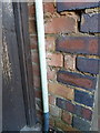
OS benchmark - Wells Green, 48 Coalway Road
Barely visible behind the gas pipe, there is in fact a rather unloved OS cutmark which was originally levelled at 103.44m above Ordnance Datum Newlyn.
Image: © Richard Law
Taken: 20 Jan 2016
0.07 miles
2
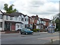
Shaftesbury Road, Birmingham 26
Linking Cranes Park Road and Mardon Road, both named after the suburb's 1930s developers.
Image: © Christine Johnstone
Taken: 16 May 2012
0.13 miles
3
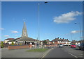
Sheaf Lane Sheldon Church of St Thomas More
Image: © Roy Hughes
Taken: 7 Mar 2016
0.13 miles
4
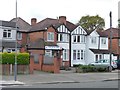
Cranes Park Road Surgery
There has been a GP's surgery here since for at least 60 years, gradually extending backwards.
Image: © Christine Johnstone
Taken: 16 May 2012
0.14 miles
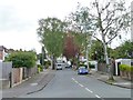
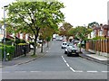
5
No 60 bus stop, Cranes Park Road
In front of a mix of unaltered, extended and terraced semis.
Image: © Christine Johnstone
Taken: 16 May 2012
0.14 miles
6

Interior of Church of St Thomas More, Sheldon, with glass by John Chrestien.
This is a view looking away from the sanctuary towards the rear wall of the nave, showing the rise in the floor away from the sanctuary, the light streaming through the clear glass of the roof lights, and Chrestien's stained glass, include one of two windows illustrating More's heraldic moorcock and a key, depicted close up at Image
Image: © A J Paxton
Taken: 9 Sep 2023
0.14 miles
7
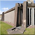
Waterspout, Church of St Thomas More, Sheldon
This view of part of the exterior of this late 1960s Catholic church by Richard Gilbert Scott shows one of a pair of chunky concrete waterspouts, also the sturdy reinforced concrete frame with corner buttresses and the windows of stained glass between concrete fins; see the listing for the church at the Historic England site https://historicengland.org.uk/listing/the-list/list-entry/1410131?section=official-list-entry . Perhaps the temples of Utopia had waterspouts like this; see More on the religions of the Utopians https://www.marxists.org/reference/archive/more/works/utopia/ch10.html .
Image: © A J Paxton
Taken: 9 Sep 2023
0.15 miles
8
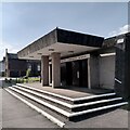
Porch of Church of St Thomas More, Sheldon
The architect, Richard Gilbert Scott, designed for a porch a freestanding canopy of reinforced concrete resting on a pair of piers. It does look a little like a chunkier version of a petrol station forecourt canopy, appropriate perhaps for Birmingham the Motor City. The original lettering of the church sign over the doors has survived. See the listing at Historic England https://historicengland.org.uk/listing/the-list/list-entry/1410131?section=official-list- .
The visit to this church formed the second part of Brutiful Birmingham's guided tour of two Richard Gilbert Scott churches in eastern Birmingham; for the first part, see Image On Brutalism as an architectural style and ethic, see the RIBA (Royal Institute of British Architects) site https://www.architecture.com/explore-architecture/brutalism .
Image: © A J Paxton
Taken: 9 Sep 2023
0.15 miles
9
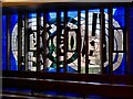
Holy Trinity window, Church of St Thomas More, Sheldon
This window by John Chrestien depicts the three persons of the Christian Godhead - Father, Son & Holy Spirit - as three interlinked circles. The church was completed in 1969.
Image: © A J Paxton
Taken: 9 Sep 2023
0.15 miles
10
Forest Hill Road, Birmingham 26
Linking Cranes Park Road and Mardon Road, named for the suburb's 1930s builders, Mardon and Kraintz.
Image: © Christine Johnstone
Taken: 16 May 2012
0.15 miles