IMAGES TAKEN NEAR TO
Moat Lane, BIRMINGHAM, B26 1TJ
Introduction
This page details the photographs taken nearby to Moat Lane, B26 1TJ by members of the Geograph project.
The Geograph project started in 2005 with the aim of publishing, organising and preserving representative images for every square kilometre of Great Britain, Ireland and the Isle of Man.

There are currently over 7.5m images from over14,400 individuals and you can help contribute to the project by visiting https://www.geograph.org.uk
Image Map
Images are licensed for reuse under creativecommons.org/licenses/by-sa/2.0
Notes
- Clicking on the map will re-center to the selected point.
- The higher the marker number, the further away the image location is from the centre of the postcode.
Image Listing (6 Images Found)
Images are licensed for reuse under creativecommons.org/licenses/by-sa/2.0
Image
Details
Distance
1

Digbeth in the Field United Reformed Church
On Moat Lane, Gilbertstone.
Image: © Richard Law
Taken: 4 Jul 2014
0.19 miles
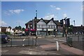
2
The William Tyler
Wetherspoons public house on Yew Tree Lane, Yardley.
Image: © Ian S
Taken: 26 Jul 2021
0.20 miles
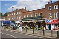
3
Shops on Church Road, Yardley
The road on the right is Yew Tree Lane.
Image: © Peter Whatley
Taken: 7 Dec 2011
0.20 miles
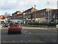
6
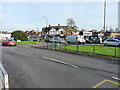
Junction of Hob Moor Road with Church Road, Yardley
A busy traffic roundabout between Yardley & Gilbertstone.
Image: © Richard Law
Taken: 24 Nov 2014
0.23 miles