IMAGES TAKEN NEAR TO
Minstead Road, BIRMINGHAM, B24 8PT
Introduction
This page details the photographs taken nearby to Minstead Road, B24 8PT by members of the Geograph project.
The Geograph project started in 2005 with the aim of publishing, organising and preserving representative images for every square kilometre of Great Britain, Ireland and the Isle of Man.

There are currently over 7.5m images from over14,400 individuals and you can help contribute to the project by visiting https://www.geograph.org.uk
Image Map
Images are licensed for reuse under creativecommons.org/licenses/by-sa/2.0
Notes
- Clicking on the map will re-center to the selected point.
- The higher the marker number, the further away the image location is from the centre of the postcode.
Image Listing (147 Images Found)
Images are licensed for reuse under creativecommons.org/licenses/by-sa/2.0
Image
Details
Distance
2
Aston under snow 10 - Birmingham
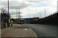
Taken from under the M6, near the junction of the Birmingham and Fazeley Canal with the Grand Union Canal, the motorway is paralleled by the A38 in the background, striding across the landscape on concrete stilts. Time taken 9.37 am GMT (Greenwich Mean Time).
Image: © Martin Richard Phelan
Taken: 14 Jan 2010
0.10 miles
3
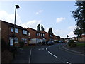
A38, elevated road
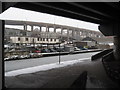
Part of spaghetti junction at this point.
Image: © N Chadwick
Taken: 24 Jun 2012
0.11 miles
4
Birmingham and Fazeley Canal near Gravelly Hill, Birmingham
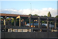
This is just east of Salford Junction (for the canal) and Spaghetti Junction (for the M6 motorway), elevated on the right. The River Tame flows through the trees to the right of the motorway pillars.
Image: © Roger D Kidd
Taken: 9 Sep 2008
0.11 miles
5
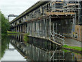
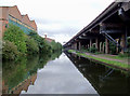
Canal, M6 flyover and scaffolding near Gravelly Hill
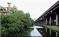
This is the Birmingham and Fazeley Canal looking south-east from Salford Junction.
Image: © Roger D Kidd
Taken: 29 Aug 2012
0.11 miles
6
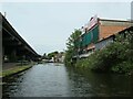
Canalside building with advert at Salford Junction
'Advertise your business here' is aimed at people using the MG viaduct, not those using the Birmingham & Fazeley canal.
Image: © Christine Johnstone
Taken: 9 May 2022
0.11 miles
7
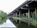
Birmingham and Fazeley Canal near Gravelly Hill, Birmingham
This is just east of Salford Junction (for the canal) and Spaghetti Junction (for the M6 motorway), elevated on the right. The River Tame flows through the trees to the right of the motorway pillars.
Image: © Roger D Kidd
Taken: 9 Sep 2008
0.11 miles
9
Birmingham and Fazeley Canal near Gravelly Hill, Birmingham
This is just east of Salford Junction (for the canal) and Spaghetti Junction (for the M6 motorway), elevated on the right. The River Tame flows through the trees to the right of the motorway pillars.
Image: © Roger D Kidd
Taken: 9 Sep 2008
0.11 miles
10
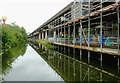
Canal and M6 flyover near Gravelly Hill, Birmingham
This is the Birmingham and Fazeley Canal looking south-east from Salford Junction.
Image: © Roger D Kidd
Taken: 29 Aug 2012
0.11 miles