IMAGES TAKEN NEAR TO
Montpelier Road, BIRMINGHAM, B24 8EB
Introduction
This page details the photographs taken nearby to Montpelier Road, B24 8EB by members of the Geograph project.
The Geograph project started in 2005 with the aim of publishing, organising and preserving representative images for every square kilometre of Great Britain, Ireland and the Isle of Man.

There are currently over 7.5m images from over14,400 individuals and you can help contribute to the project by visiting https://www.geograph.org.uk
Image Map
Images are licensed for reuse under creativecommons.org/licenses/by-sa/2.0
Notes
- Clicking on the map will re-center to the selected point.
- The higher the marker number, the further away the image location is from the centre of the postcode.
Image Listing (36 Images Found)
Images are licensed for reuse under creativecommons.org/licenses/by-sa/2.0
Image
Details
Distance
1
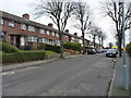
Erdington Hall Road
Residential street in the Birches Green area of north Brum.
Image: © Richard Law
Taken: 28 Feb 2017
0.04 miles
2
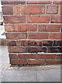
OS benchmark - Birhces Green, 15 Erdington Hall Road
An OS cutmark on the side wall of the house; originally levelled at 103.5m above Ordnance Datum Newlyn.
Image: © Richard Law
Taken: 28 Feb 2017
0.05 miles

4
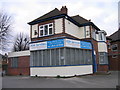
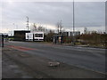
Site of Midland Bank Tyburn Road 40-11-07
I worked for Midland Bank HSBC for 32 years and spent all but the last two in Birmingham Branches. I am photographing all the branches, or what's left of them, as they were when I joined Midland Bank in 1963. The branches all start with the sorting code 40-11.
This is the 450 Tyburn Road, sub-office as occupied by Midland Bank in 1963. It was manned daily by staff from the parent branch at Erdington. It had the same sorting code of 40-11-07 as the parent branch.
Image: © Roy Hughes
Taken: 27 Dec 2008
0.14 miles
5
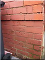
OS benchmark - Gravelly Hill, 84 Erdington Hall Road
An OS cutmark on the side wall of the house, normally hidden behind the wheelie bin. We had to move the bin to expose it. Originally levelled at 102.06m above Ordnance Datum Newlyn.
Image: © Richard Law
Taken: 28 Feb 2017
0.15 miles
7
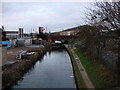
Bromford Lane bridge over canal
A view north-eastwards from Wheelwright Road bridge.
Image: © David
Taken: 27 Dec 2007
0.17 miles
8
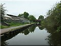
Birmingham and Fazeley Canal near Birches Green , Birmingham
This is the canal looking east from below Bromford Bridge No 1 towards Bromford Bridge No 2.
The Birmingham and Fazeley Canal was completed in 1789 having been engineered and supervised by John Smeaton. It linked Birmingham (Farmer's Bridge Junction) with the Coventry Canal at Fazeley Junction. It is fifteen miles in length, with 38 locks. An extension to the north-west along part of the Coventry Canal route to Whittington was added later.
Image: © Roger D Kidd
Taken: 29 Aug 2012
0.17 miles
9
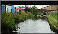
Birmingham & Fazeley canal
Looking south-west between Bromford Bridge No 2 and Bromford Bridge No 1.
Image: © Christine Johnstone
Taken: 9 May 2022
0.17 miles
10
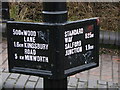
Signpost on Fazeley Canal
Pity on such an old method of transport we've gone metric!
Image: © David
Taken: 27 Dec 2007
0.17 miles