IMAGES TAKEN NEAR TO
Coppice Close, BIRMINGHAM, B24 8DU
Introduction
This page details the photographs taken nearby to Coppice Close, B24 8DU by members of the Geograph project.
The Geograph project started in 2005 with the aim of publishing, organising and preserving representative images for every square kilometre of Great Britain, Ireland and the Isle of Man.

There are currently over 7.5m images from over14,400 individuals and you can help contribute to the project by visiting https://www.geograph.org.uk
Image Map
Images are licensed for reuse under creativecommons.org/licenses/by-sa/2.0
Notes
- Clicking on the map will re-center to the selected point.
- The higher the marker number, the further away the image location is from the centre of the postcode.
Image Listing (33 Images Found)
Images are licensed for reuse under creativecommons.org/licenses/by-sa/2.0
Image
Details
Distance
3
Oakfield Road / Wood End Road
Road junction - outer ring road, close to six ways Erdington (off to the left)
Image: © Michael Westley
Taken: 18 Aug 2010
0.08 miles
4
Erdington Six Ways Baptist Church
Website: http://www.eccc.org.uk/SixWaysBaptist.htm
Image: © Geoff Pick
Taken: 9 Jul 2010
0.08 miles
5
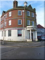
Laiki Bank, Six Ways Island
The former Lloyds or Midland Bank building in Erdington. The cast-iron downpipe collectors show a date of 1923 or 1925, so it's been here nearly a century, but was most recently operating as Laiki Bank, a trading arm of the Cyprus Popular Bank. That business was transferred to the Bank of Cyprus UK in early 2013.
Image: © Richard Law
Taken: 28 Feb 2017
0.10 miles
7
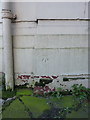
OS benchmark - Erdington, bank at Six Ways island
An OS cutmark on the former Lloyds(?) Bank building at the Six Ways Island; originally levelled in 1956 at 122.292m above Ordnance Datum Newlyn.
Image: © Richard Law
Taken: 28 Feb 2017
0.10 miles
8
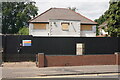
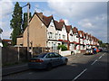
A boarded-up house
This seems to have been empty for some time, but there is no indication that there are any plans for it.
Image: © Bill Boaden
Taken: 29 Jun 2023
0.10 miles
10
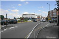
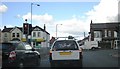
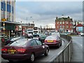
Six Ways Island, Erdington
A busy junction. High Street seen towards the right is no longer the main road for traffic but is still a busy commercial street, with a selection of diverse retailers.
Image: © Bill Boaden
Taken: 29 Jun 2023
0.13 miles