IMAGES TAKEN NEAR TO
Blossom Road, BIRMINGHAM, B24 0UD
Introduction
This page details the photographs taken nearby to Blossom Road, B24 0UD by members of the Geograph project.
The Geograph project started in 2005 with the aim of publishing, organising and preserving representative images for every square kilometre of Great Britain, Ireland and the Isle of Man.

There are currently over 7.5m images from over14,400 individuals and you can help contribute to the project by visiting https://www.geograph.org.uk
Image Map
Images are licensed for reuse under creativecommons.org/licenses/by-sa/2.0
Notes
- Clicking on the map will re-center to the selected point.
- The higher the marker number, the further away the image location is from the centre of the postcode.
Image Listing (10 Images Found)
Images are licensed for reuse under creativecommons.org/licenses/by-sa/2.0
Image
Details
Distance
1
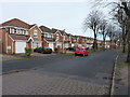
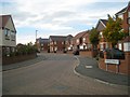
New housing on Paget Road
I'd agree with the comments in Image about these houses being a redevelopment of the area - the size of the trees suggests that they lined a road which pre-dates the current buildings.
Image: © Richard Law
Taken: 28 Feb 2017
0.03 miles
2
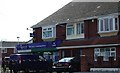
Michael's Supermarket
On corner of Springthorpe Road and Springthorpe Green, amongst recently revitalised and new housing on Paget Estate
Image: © Michael Westley
Taken: 18 Apr 2010
0.08 miles
3
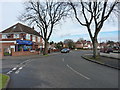
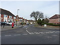
Springthorpe Road
At the junction with Springthorpe Green, where a small shop serves the day-to-day needs of the residents.
Image: © Richard Law
Taken: 28 Feb 2017
0.11 miles
4
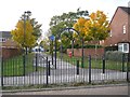
Paget Green and path to Paget Primary School, Pype Hayes
Together with Varley Road behind the camera this path is on the axis of the original council estate; St Mary's Church (built 1930) is at the eastern end.
Image: © Robin Stott
Taken: 20 Oct 2012
0.11 miles
5
Woodcote Road
Looking up Woodcote Road from its junction with Springthorpe Road
Image: © Richard Law
Taken: 28 Feb 2017
0.12 miles
6
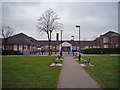
Paget Primary School
Paget Primary school sits at the heart of a regeneration housing development in Birmingham's Erdington district
Image: © Mark Walton
Taken: 23 Mar 2007
0.16 miles
7
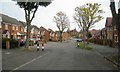
Old trees, new houses, Varley Road, Pype Hayes
This area appears to be a former council estate that has been almost completely rebuilt as private housing. Varley Road was the formal axis, with St Mary's Church at the eastern end, here seen in the distance, and the Paget School at the western end, behind the camera. The original straight road has been remodelled to prevent speeding. A view from 2017 is Richard Law's Image
Image: © Robin Stott
Taken: 20 Oct 2012
0.18 miles
8
Sharp bend on Springthorpe Road, Pype Hayes
A presumed former council estate has been almost completely rebuilt as private housing.
Image: © Robin Stott
Taken: 20 Oct 2012
0.19 miles
9
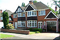
Beeches Drive, Erdington, Birmingham.
Typical semi-detached houses on this estate, circa 1938.
Image: © Alan Spencer
Taken: 15 May 2008
0.21 miles
10
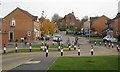
Traffic calming, east end of Varley Road, Pype Hayes
This area appears to be a former council estate that has been almost completely rebuilt as private housing. Varley Road was the formal axis, with St Mary's Church at the eastern end, here seen in the distance, and the Paget School at the western end, behind the camera. The original straight road has been remodelled to prevent speeding.
Image: © Robin Stott
Taken: 20 Oct 2012
0.22 miles