IMAGES TAKEN NEAR TO
Tyburn Road, BIRMINGHAM, B24 0TP
Introduction
This page details the photographs taken nearby to Tyburn Road, B24 0TP by members of the Geograph project.
The Geograph project started in 2005 with the aim of publishing, organising and preserving representative images for every square kilometre of Great Britain, Ireland and the Isle of Man.

There are currently over 7.5m images from over14,400 individuals and you can help contribute to the project by visiting https://www.geograph.org.uk
Image Map
Images are licensed for reuse under creativecommons.org/licenses/by-sa/2.0
Notes
- Clicking on the map will re-center to the selected point.
- The higher the marker number, the further away the image location is from the centre of the postcode.
Image Listing (29 Images Found)
Images are licensed for reuse under creativecommons.org/licenses/by-sa/2.0
Image
Details
Distance
1
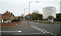
East-northeast on Tyburn Road B4148
The view is from the corner of Pype Hayes Road. The block of flats is called Sorrel House.
Image: © Robin Stott
Taken: 20 Oct 2012
0.07 miles
2
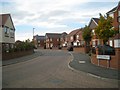
Sharp bend on Springthorpe Road, Pype Hayes
A presumed former council estate has been almost completely rebuilt as private housing.
Image: © Robin Stott
Taken: 20 Oct 2012
0.14 miles
3
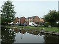
Houses on Kimble Grove, Erdington
On the north bank of the Birmingham & Fazeley canal.
Image: © Christine Johnstone
Taken: 9 May 2022
0.15 miles
4
Houses on Kimble Grove
From the Birmingham and Fazeley Canal.
Image: © Andrew Abbott
Taken: 15 Sep 2022
0.16 miles
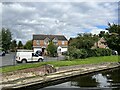
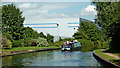
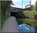
5
Birmingham and Fazeley Canal near Butler's Bridge
Image: © David Martin
Taken: 19 Jul 2016
0.16 miles
6
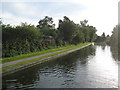
Birmingham & Fazeley Canal: Reach near Tyburn
The canal cuts across the south-eastern corner of this grid square. Image is just around the corner to the left at the end of this straight section.
Image: © Nigel Cox
Taken: 8 Sep 2012
0.17 miles
7
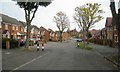
Old trees, new houses, Varley Road, Pype Hayes
This area appears to be a former council estate that has been almost completely rebuilt as private housing. Varley Road was the formal axis, with St Mary's Church at the eastern end, here seen in the distance, and the Paget School at the western end, behind the camera. The original straight road has been remodelled to prevent speeding. A view from 2017 is Richard Law's Image
Image: © Robin Stott
Taken: 20 Oct 2012
0.18 miles
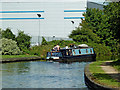
8
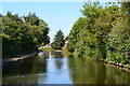
Birmingham and Fazeley Canal near Tyburn, Birmingham
Looking north-east towards Fazeley.
Image: © Roger Kidd
Taken: 20 Aug 2012
0.19 miles
10
Birmingham and Fazeley Canal near Tyburn, Birmingham
A telephoto assisted image, looking north-east towards Fazeley.
Image: © Roger Kidd
Taken: 20 Aug 2012
0.19 miles