IMAGES TAKEN NEAR TO
Halford Grove, BIRMINGHAM, B24 0RX
Introduction
This page details the photographs taken nearby to Halford Grove, B24 0RX by members of the Geograph project.
The Geograph project started in 2005 with the aim of publishing, organising and preserving representative images for every square kilometre of Great Britain, Ireland and the Isle of Man.

There are currently over 7.5m images from over14,400 individuals and you can help contribute to the project by visiting https://www.geograph.org.uk
Image Map
Images are licensed for reuse under creativecommons.org/licenses/by-sa/2.0
Notes
- Clicking on the map will re-center to the selected point.
- The higher the marker number, the further away the image location is from the centre of the postcode.
Image Listing (28 Images Found)
Images are licensed for reuse under creativecommons.org/licenses/by-sa/2.0
Image
Details
Distance
1

Northeast end of Tyburn Road B4148
The junction with Chester Road A452 is ahead.
Image: © Robin Stott
Taken: 20 Oct 2012
0.05 miles
2
Bagot "Ams" pub. Chester Road Pype Hayes.
The sign has lost its "R" and should, of course, be the Bagot Arms. Situated at the Chester Road, Eachelhurst Road island.
Image: © Roy Hughes
Taken: 4 Mar 2009
0.07 miles
4
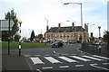
Bagot Arms, Pype Hayes
The pub overlooks the junction of the A452 Chester Road and Tyburn Road, foreground, and its continuation north Eachelhurst Road.
Image: © Robin Stott
Taken: 20 Oct 2012
0.08 miles
5
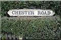
Chester Road cast iron street nameplate
Image: © Robin Stott
Taken: 20 Oct 2012
0.08 miles
6
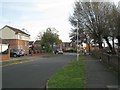
Southeast on Padstow Road, Pype Hayes
The junction with Tyburn Road B4148 is ahead.
Image: © Robin Stott
Taken: 20 Oct 2012
0.10 miles
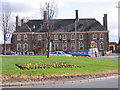
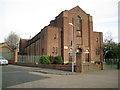
7
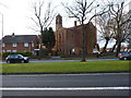
St Mary's Church, Tyburn
Designed and built in the late 1920s (1929/1930) by the architect E.F. Reynolds in a Byzantine/Romanesque style. The church and its adjoning Church Hall Image to the north were Grade II listed https://britishlistedbuildings.co.uk/101235495-church-of-st-mary-and-church-hall-tyburn-ward#.XsKUQGhKjcs & https://historicengland.org.uk/listing/the-list/list-entry/1235495 in 1995.
Image: © Richard Law
Taken: 11 Mar 2020
0.12 miles
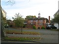
8
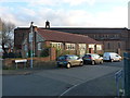
St Mary's Church Hall, Tyburn
Part of the 1929/1930 development of the main St Mary's church seen behind, the church hall was included in the 1995 Grade II listing https://britishlistedbuildings.co.uk/101235495-church-of-st-mary-and-church-hall-tyburn-ward#.XsKUQGhKjcs & https://historicengland.org.uk/listing/the-list/list-entry/1235495
Image: © Richard Law
Taken: 11 Mar 2020
0.13 miles
9
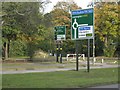
Trunk road signs, A452 Chester Road, Pype Hayes
Southbound Chester Road approaches the junction with B4148 Tyburn Road and its continuation north Eachelhurst Road. Pype Hayes Park in the background.
Image: © Robin Stott
Taken: 20 Oct 2012
0.13 miles
10
St Mary's Church, St Mary's Close, Pype Hayes
This large red brick church was designed by E.F.Reynolds and completed in 1930. It is at one end of the axis of a former council estate that has been rebuilt as private housing. The Paget School was and still is at the western end. The straight axial Varley Road has been remodelled and traffic-calmed as Hale Grove, Varley Road and Paget Green.
Image: © Robin Stott
Taken: 20 Oct 2012
0.14 miles