IMAGES TAKEN NEAR TO
Sowerby March, BIRMINGHAM, B24 0LH
Introduction
This page details the photographs taken nearby to Sowerby March, B24 0LH by members of the Geograph project.
The Geograph project started in 2005 with the aim of publishing, organising and preserving representative images for every square kilometre of Great Britain, Ireland and the Isle of Man.

There are currently over 7.5m images from over14,400 individuals and you can help contribute to the project by visiting https://www.geograph.org.uk
Image Map
Images are licensed for reuse under creativecommons.org/licenses/by-sa/2.0
Notes
- Clicking on the map will re-center to the selected point.
- The higher the marker number, the further away the image location is from the centre of the postcode.
Image Listing (63 Images Found)
Images are licensed for reuse under creativecommons.org/licenses/by-sa/2.0
Image
Details
Distance
1
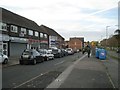
Local shops by A452 Chester Road, Pype Hayes
Image: © Robin Stott
Taken: 20 Oct 2012
0.03 miles
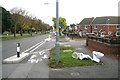
2
Speed camera, A452 Chester Road, Pype Hayes
The speed limit is 40 mph. This speed, sorry, safety camera and its counterpart on the other carriageway are shown on the AZ street atlas. They're on the approach to a relatively sharp bend on this fast, busy road. In the background is Pype Hayes Park.
Image: © Robin Stott
Taken: 20 Oct 2012
0.05 miles
3
Discarded WC pans by A452 Chester Road, Pype Hayes
Near the corner of Pype Hayes Road, right. The current Google aerial photo (November 2013) shows this part of the road coned off, probably to construct the three bollarded islands that separate the cycleway from the main carriageway. There are two bright white objects on the verge. They can be seen from space!
Image: © Robin Stott
Taken: 20 Oct 2012
0.10 miles
4
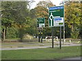
Trunk road signs, A452 Chester Road, Pype Hayes
Southbound Chester Road approaches the junction with B4148 Tyburn Road and its continuation north Eachelhurst Road. Pype Hayes Park in the background.
Image: © Robin Stott
Taken: 20 Oct 2012
0.12 miles
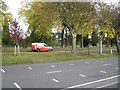
5
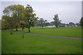
Pype Hayes Park
In the distance a fun fair is setting up.
Image: © Mick Garratt
Taken: 9 Oct 2010
0.12 miles
6
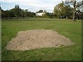
Bare patch in the grass, Pype Hayes Park
In the distance is Pype Hayes Hall.
Image: © Robin Stott
Taken: 20 Oct 2012
0.14 miles
8
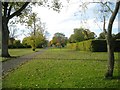
Pype Hayes Park and Hall
Mature trees and parkland at Pype Hayes
Image: © Michael Westley
Taken: 29 Apr 2005
0.14 miles
9
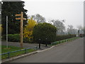
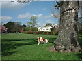
Cycling route, Pype Hayes Park
Fingerpost on driveway next to tennis courts in the park.
Signs give directions to Pitts Farm estate, Penns Lane, New Hall Valley, Sutton Coldfield, Chester Road, Birmingham & Fazeley Canal, and (the eventual link up of sustrans route) Birmingham City Centre (5.25 miles away)
Image: © Michael Westley
Taken: 26 Mar 2011
0.15 miles
10
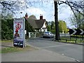
Entrance to Pype Hayes Park
Entrance to car park, off Chester Road, Pype Hayes. Small gatehouse is regularly occupied and maintained by council.
Image: © Michael Westley
Taken: 18 Apr 2010
0.15 miles