IMAGES TAKEN NEAR TO
Hayes Grove, BIRMINGHAM, B24 0HR
Introduction
This page details the photographs taken nearby to Hayes Grove, B24 0HR by members of the Geograph project.
The Geograph project started in 2005 with the aim of publishing, organising and preserving representative images for every square kilometre of Great Britain, Ireland and the Isle of Man.

There are currently over 7.5m images from over14,400 individuals and you can help contribute to the project by visiting https://www.geograph.org.uk
Image Map
Images are licensed for reuse under creativecommons.org/licenses/by-sa/2.0
Notes
- Clicking on the map will re-center to the selected point.
- The higher the marker number, the further away the image location is from the centre of the postcode.
Image Listing (36 Images Found)
Images are licensed for reuse under creativecommons.org/licenses/by-sa/2.0
Image
Details
Distance
1
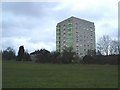
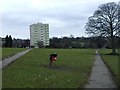
Little Hill House flats, Pype Hayes Park
View from footpath near to Hervey Grove gulley into park.
Image: © Michael Westley
Taken: 6 Mar 2010
0.03 miles
2
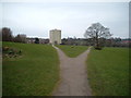
A flat view from Pype Hayes Park
A short walk into the park from the public car park brings you to this split in the path
Image: © Mark Walton
Taken: 23 Mar 2007
0.03 miles
3
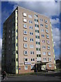
Little Hill House Flats, Hayes Grove Erdington
A view of the sheltered housing block of flats seen in the distance on view Image
Image: © Roy Hughes
Taken: 4 Mar 2009
0.04 miles
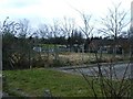
4
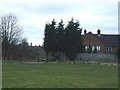
Hervey Grove gulley to park
View from park of gulley to Hervey Grove. Where once were council housing estates and flats, there currently only stands a handful of privately owned houses. Now awaiting redevelopment of land.
http://en.wikipedia.org/wiki/Pype_Hayes
Image: © Michael Westley
Taken: 6 Mar 2010
0.05 miles
5
Park view, Pype Hayes Park
View of paths dividing west, towards Hayes Grove Image] or Hervey Grove on the western edge of the park.
Image: © Michael Westley
Taken: 6 Mar 2010
0.06 miles
6
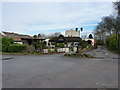
The Digby, Pype Hayes
A small pub tucked away quietly just off the A452 Chester Road.
Image: © Richard Law
Taken: 28 Feb 2017
0.09 miles
7
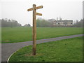
New Fingerpost - Pype Hayes Park
On upgraded footpath (cycle friendly),just into the park, to east of Pype Hayes estate. Looking south towards flats in Park Close off Chester Road
Image: © Michael Westley
Taken: 26 Mar 2011
0.09 miles
8
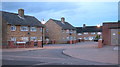
Blithfield Grove off Pitts Farm Road
On Pitts Farm Estate, some redevelopment has taken place, close to newest housing estate (opposite side of PFR)
Image: © Michael Westley
Taken: 28 Aug 2010
0.09 miles
9
Chase Grove, Pype Hayes
Awaiting new housing developments, an area fenced off once had 2 storey council housing. Behind are privately owned houses. In the background Image]
Image: © Michael Westley
Taken: 6 Mar 2010
0.10 miles
10
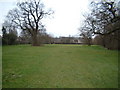
Pype Hayes Park's South west boundary
This photo shows the park's South west boundary
Image: © Mark Walton
Taken: 23 Mar 2007
0.12 miles