IMAGES TAKEN NEAR TO
Grange Road, BIRMINGHAM, B24 0DG
Introduction
This page details the photographs taken nearby to Grange Road, B24 0DG by members of the Geograph project.
The Geograph project started in 2005 with the aim of publishing, organising and preserving representative images for every square kilometre of Great Britain, Ireland and the Isle of Man.

There are currently over 7.5m images from over14,400 individuals and you can help contribute to the project by visiting https://www.geograph.org.uk
Image Map
Images are licensed for reuse under creativecommons.org/licenses/by-sa/2.0
Notes
- Clicking on the map will re-center to the selected point.
- The higher the marker number, the further away the image location is from the centre of the postcode.
Image Listing (14 Images Found)
Images are licensed for reuse under creativecommons.org/licenses/by-sa/2.0
Image
Details
Distance
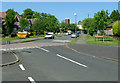
1
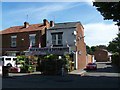
Ghaf Newsagent & Supermarket
At 174 Holly Lane, Erdington
Image: © Geoff Pick
Taken: 9 Jul 2010
0.13 miles
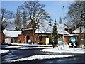
3
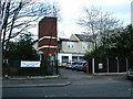
John Taylor Hospice
On Grange Road, Erdington
Image: © Michael Westley
Taken: 18 Apr 2010
0.17 miles
4
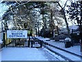
Mason Cottages, Orphanage Road, Erdington
Entrance to grounds of homes managed by the Josiah Mason Trust, built around the time that the orphanage was demolished, on site retained for housing.
Image: © Michael Westley
Taken: 6 Jan 2010
0.18 miles
5
Holly Lane United Reformed Church, Erdington
Church on corner of Orphanage Road and Holly Lane
Image: © Michael Westley
Taken: 6 Jan 2010
0.19 miles
6
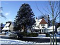
Winter's Scene, Orphanage Road, Erdington
Almost opposite Mason Cottages, is a house with a fantastic monkey tree.
Image: © Michael Westley
Taken: 6 Jan 2010
0.20 miles
7
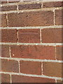
OS benchmark - Erdington, United Reformed Church
An OS cutmark on the side wall of Image (it's roughly behind the yellow sign in that picture) which was originally levelled at 123.85m above Ordnance Datum Newlyn.
Image: © Richard Law
Taken: 28 Feb 2017
0.20 miles
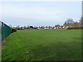
8
Moor End Lane, Erdington, Birmingham.
Houses built on the site of Moor End Lane Primary School.
Image: © Alan Spencer
Taken: 15 May 2008
0.22 miles
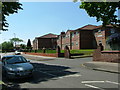
9
Cedar Drive, Erdington, Birmingham
Entrance drive to Beeches Drive and Chestnut Drive.
Image: © Alan Spencer
Taken: 15 May 2008
0.22 miles
10
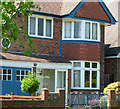
House in Cedar Drive, Erdington, Birmingham
Typical detached house in Cedar Drive, circa 1938.
Image: © Alan Spencer
Taken: 15 May 2008
0.22 miles