IMAGES TAKEN NEAR TO
Silver Birch Road, BIRMINGHAM, B24 0AS
Introduction
This page details the photographs taken nearby to Silver Birch Road, B24 0AS by members of the Geograph project.
The Geograph project started in 2005 with the aim of publishing, organising and preserving representative images for every square kilometre of Great Britain, Ireland and the Isle of Man.

There are currently over 7.5m images from over14,400 individuals and you can help contribute to the project by visiting https://www.geograph.org.uk
Image Map
Images are licensed for reuse under creativecommons.org/licenses/by-sa/2.0
Notes
- Clicking on the map will re-center to the selected point.
- The higher the marker number, the further away the image location is from the centre of the postcode.
Image Listing (80 Images Found)
Images are licensed for reuse under creativecommons.org/licenses/by-sa/2.0
Image
Details
Distance
1
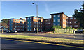
Yenton Court flats, Chester Road, Erdington, north Birmingham
They first appear on a map of 1963-64. This is the northern end of Erdington.
Image: © Robin Stott
Taken: 24 Jun 2018
0.04 miles
2
Samantabhadra, Erdington
Buddhist Meditation Centre on Silver Birch Road
Image: © Michael Westley
Taken: 24 Nov 2010
0.04 miles
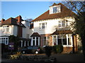
3
St Josephs Residential Care Home
Silver Birch Road, Erdington
Image: © Michael Westley
Taken: 24 Nov 2010
0.08 miles
4
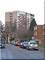
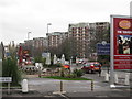
Kentmere Tower, Lyndhurst Estate, Erdington
View northward along Silver Birch Road towards Lyndhurst Estate on Sutton Road. Kentmere Tower is visible. The estate was built in 1960 and can be seen from many miles away on high ground. Further details at http://ukhousing.wikia.com/wiki/Lyndhurst_estate
Image: © Michael Westley
Taken: 22 Nov 2009
0.09 miles
5
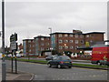
Yenton Court, Chester Road, Erdington
Sets of flats on southern side of Chester Road, next door to McDonald's and opposite Tesco Express / petrol station.
Image: © Michael Westley
Taken: 28 Nov 2009
0.10 miles
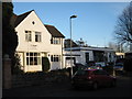
6
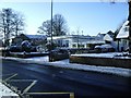
Winter's Scene, Orphanage Road, Erdington
Unusual single-storey property on corner of Orphanage Road and Silver Birch Road.
Image: © Michael Westley
Taken: 6 Jan 2010
0.10 miles
7
The Yenton, Public House, Sutton Road, Erdington
Outside seating at pub on Sutton Road (for summers / smokers). View of estate in distance, from corner of Douay Road and Sutton Road. The pub hoarding on right is recent addition since the rebranding of the pub to 'Sizzling' - yes, good food !
Image: © Michael Westley
Taken: 28 Nov 2009
0.10 miles
8
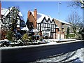
Winter's Scene, Orphanage Road, Erdington
More distinguished homes on Orphanage Road. Two-storey flats to the right are on corner of Silver Birch Road / Orphanage Road.
Image: © Michael Westley
Taken: 6 Jan 2010
0.11 miles
9
Chester Road looking south west
A new apartment block is going up on the corner with Orphanage Road.
On the left is the forecourt of Clover Spa a naturist (clothing optional to be more precise) Hotel and spa.
Image: © David Lally
Taken: 28 Jan 2017
0.11 miles
10
Kentmere Tower, post renovations
High rise block of flats on Lyndhurst Estate after completion of 'make-over'
Compare to Image]
Image: © Michael Westley
Taken: 27 Nov 2011
0.11 miles