IMAGES TAKEN NEAR TO
Gravelly Hill, BIRMINGHAM, B23 7JY
Introduction
This page details the photographs taken nearby to Gravelly Hill, B23 7JY by members of the Geograph project.
The Geograph project started in 2005 with the aim of publishing, organising and preserving representative images for every square kilometre of Great Britain, Ireland and the Isle of Man.

There are currently over 7.5m images from over14,400 individuals and you can help contribute to the project by visiting https://www.geograph.org.uk
Image Map
Images are licensed for reuse under creativecommons.org/licenses/by-sa/2.0
Notes
- Clicking on the map will re-center to the selected point.
- The higher the marker number, the further away the image location is from the centre of the postcode.
Image Listing (133 Images Found)
Images are licensed for reuse under creativecommons.org/licenses/by-sa/2.0
Image
Details
Distance
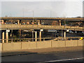
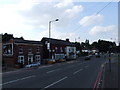
3
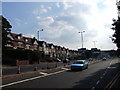
Salford Circus, Gravelly Hill
Salford Circus forms part of the Gravelly Hill Interchange.
Image: © Chris Whippet
Taken: 30 Jul 2014
0.09 miles
4
A5127 meets the A38(M), Gravelly Hill
Image: © Chris Whippet
Taken: 30 Jul 2014
0.09 miles
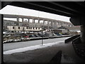
5
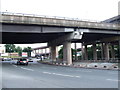
Spaghetti Junction
Gravelly Hill Interchange is junction 6 of the M6 motorway where it meets the A38 Aston Expressway in the Gravelly Hill area of Birmingham. Opened in 1972, It is perhaps more well known by its nickname of "Spaghetti Junction".
This infamous junction provides the interchange between the M6, A38(M), A38, A5127 and an unclassified road. It does this by means of a complex array of slip roads and a roundabout.
Image: © David Dixon
Taken: 17 Dec 2012
0.10 miles
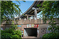
6
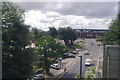
Aston under snow 10 - Birmingham
Taken from under the M6, near the junction of the Birmingham and Fazeley Canal with the Grand Union Canal, the motorway is paralleled by the A38 in the background, striding across the landscape on concrete stilts. Time taken 9.37 am GMT (Greenwich Mean Time).
Image: © Martin Richard Phelan
Taken: 14 Jan 2010
0.10 miles
7
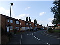
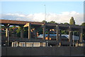
South end of Slade Road, Gravelly Hill, Birmingham
In the distance is the eastern section of Spaghetti Junction, M6 Junction 6. At high level is the exit from the Aston Expressway, A38 (M), towards the A38 Tyburn Road, out of sight left. Traffic can be seen on the M6 beyond the Expressway at low level. The view is from a London Midland local train towards Birmingham as it crosses Slade Road.
Image: © Robin Stott
Taken: 25 Jul 2016
0.11 miles
8
A38, elevated road
Part of spaghetti junction at this point.
Image: © N Chadwick
Taken: 24 Jun 2012
0.11 miles
10
Inside Salford Circus, Gravelly Hill Interchange
Within the "Local Roads" part of M6 Junction 6. The centre of the roundabout is a pedestrianised area, featuring five subways giving safe access (in theory) between one road and the next. The subway ahead gives access to Copeley Hill. The elevated roadway above is the route from the A38(M) Aston Expressway to A38 Tyburn Road.
Image: © Oliver Mills
Taken: 3 Jun 2022
0.12 miles