IMAGES TAKEN NEAR TO
Queens Road, BIRMINGHAM, B23 7JP
Introduction
This page details the photographs taken nearby to Queens Road, B23 7JP by members of the Geograph project.
The Geograph project started in 2005 with the aim of publishing, organising and preserving representative images for every square kilometre of Great Britain, Ireland and the Isle of Man.

There are currently over 7.5m images from over14,400 individuals and you can help contribute to the project by visiting https://www.geograph.org.uk
Image Map
Images are licensed for reuse under creativecommons.org/licenses/by-sa/2.0
Notes
- Clicking on the map will re-center to the selected point.
- The higher the marker number, the further away the image location is from the centre of the postcode.
Image Listing (14 Images Found)
Images are licensed for reuse under creativecommons.org/licenses/by-sa/2.0
Image
Details
Distance
1

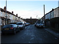
Former off-licence
Last used as the premises of 'Lester Virgo [who] is licensed to sell, by retail, intoxicating liquor of all descriptions for consumption off the premises'. Judging by the state of the place, that was some while ago.
Image: © Richard Law
Taken: 9 Aug 2017
0.11 miles
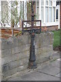
2
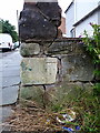
OS benchmark - Stockland Green, 197 George Road
An OS cutmark on the rather shonky boundary wall of 197 George Road, at the junction with Mere Road. It was levelled, probably in 1956, at 101.91m above Ordnance Datum Newlyn.
Image: © Richard Law
Taken: 9 Aug 2017
0.13 miles
3
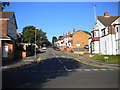
Mere Road, Stockland Green
A residential road linking George Road (foreground) with Slade Road.
Image: © Richard Vince
Taken: 22 Sep 2013
0.14 miles
6
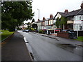
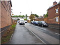
A damp morning in Stockland Green
Looking along a rain-soaked George Road.
Image: © Richard Law
Taken: 9 Aug 2017
0.16 miles
7
Sign of the times
Remains of former (victorian ?) street sign on Victoria Road
Image: © Michael Westley
Taken: 14 Jan 2012
0.16 miles
8
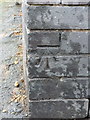
OS benchmark - Stockland Green, George Road / Neville Road
An OS cutmark on the wall at the junction of Neville Road with George Road; originally levelled, probably in 1956, at 99.77m above Ordnance Datum Newlyn.
Image: © Richard Law
Taken: 9 Aug 2017
0.16 miles
9
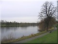
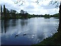
Brookvale Lake or Boating Pool.
View from George Road.
Image: © Roy Hughes
Taken: 24 Jan 2009
0.18 miles
10
Brookvale Boating Lake / Pool
View from shore of lake, near to Teal Drive homes that look out on the lake
Image: © Michael Westley
Taken: 25 Apr 2010
0.18 miles