IMAGES TAKEN NEAR TO
Knightwick Crescent, BIRMINGHAM, B23 7BX
Introduction
This page details the photographs taken nearby to Knightwick Crescent, B23 7BX by members of the Geograph project.
The Geograph project started in 2005 with the aim of publishing, organising and preserving representative images for every square kilometre of Great Britain, Ireland and the Isle of Man.

There are currently over 7.5m images from over14,400 individuals and you can help contribute to the project by visiting https://www.geograph.org.uk
Image Map
Images are licensed for reuse under creativecommons.org/licenses/by-sa/2.0
Notes
- Clicking on the map will re-center to the selected point.
- The higher the marker number, the further away the image location is from the centre of the postcode.
Image Listing (15 Images Found)
Images are licensed for reuse under creativecommons.org/licenses/by-sa/2.0
Image
Details
Distance
1
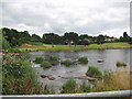
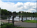
From water supply to wildlife - Witton Lakes, Birmingham
Witton Lakes were created in the 19th century as drinking water reservoirs and served this purpose until superseded by the supply from the Elan Valley reservoirs. They now support numbers of wildfowl. Time photo taken 2.53 pm BST (British Summer Time).
Image: © Martin Richard Phelan
Taken: 9 Aug 2013
0.16 miles
2
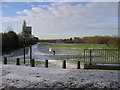
Looking towards Witton Lakes from Bleak Hill Road
The morning after the coldest night of the Winter so far.
Image: © Roy Hughes
Taken: 6 Jan 2009
0.16 miles
3
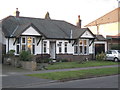
Bungalow between houses
Unusual and stylish bungalow on Bleak Hill Road, Short Heath
Image: © Michael Westley
Taken: 14 Jan 2012
0.17 miles
4
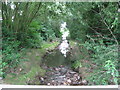
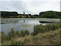
Feeders to the lakes - Witton Lakes, Birmingham
Witton Lakes are entirely artificial but are fed by two natural streams - one arising from Bleak Hill and one from Kingstanding. They were originally drinking water reservoirs created in the 19th century and they remained in use until superseded by the supply from the Elan Valley reservoirs. Time photo taken 3.07 pm BST (British Summer Time).
Image Image
Image: © Martin Richard Phelan
Taken: 9 Aug 2013
0.17 miles
5
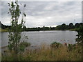
View from the dam - Witton Lakes, Birmingham
Witton Lakes were created in the 19th century as drinking water reservoirs and served this purpose until superseded by the supply from the Elan Valley reservoirs. The North Birmingham Cycle/Walk Route - no. 535 from Sutton Coldfield to Birmingham - passes through the area. Time photo taken 3.31 pm BST (British Summer Time).
Image: © Martin Richard Phelan
Taken: 4 Jun 2012
0.18 miles
6
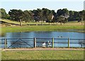
Upper Witton Reservoir
One of two lakes created by the City Corporation in the mid 19th century as public water supply, at a time when the brooks feeding them from the north flowed through clean agricultural land. The upper lake here is now a wildfowl reserve.
Image: © Richard Law
Taken: 9 Aug 2018
0.18 miles
7

Witton Lakes, off Perry Common Road
Wildlife and humanity in harmony
Image: © Michael Westley
Taken: 8 May 2016
0.18 miles
8
From water supply to a walk in the park - Witton Lakes, Birmingham
Witton Lakes were created in the 19th century as drinking water reservoirs and served this purpose until superseded by the supply from the Elan Valley reservoirs. The North Birmingham Cycle/Walk Route - no. 535 from Sutton Coldfield to Birmingham - passes through the area. Time photo taken 2.55 pm BST (British Summer Time).
Image
Image: © Martin Richard Phelan
Taken: 9 Aug 2013
0.19 miles
9
Witton Lakes
A lovely green "lung" between Perry Common, Short Heath and Upper Witton.
Image: © Adrian Bailey
Taken: 16 Jul 2005
0.21 miles
10
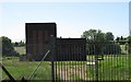
Pumping Station, Perry Common Road
Not sure if this building is still in use, former utilities building (Pumping Station) on small area of land visible from Bleak Hill Road and Perry Common Road.
Close proximity to streams and Witton lakes.
Image: © Michael Westley
Taken: 22 May 2010
0.21 miles