IMAGES TAKEN NEAR TO
Marsh Lane, BIRMINGHAM, B23 6PP
Introduction
This page details the photographs taken nearby to Marsh Lane, B23 6PP by members of the Geograph project.
The Geograph project started in 2005 with the aim of publishing, organising and preserving representative images for every square kilometre of Great Britain, Ireland and the Isle of Man.

There are currently over 7.5m images from over14,400 individuals and you can help contribute to the project by visiting https://www.geograph.org.uk
Image Map
Images are licensed for reuse under creativecommons.org/licenses/by-sa/2.0
Notes
- Clicking on the map will re-center to the selected point.
- The higher the marker number, the further away the image location is from the centre of the postcode.
Image Listing (3 Images Found)
Images are licensed for reuse under creativecommons.org/licenses/by-sa/2.0
Image
Details
Distance
1
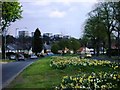
Marsh Lane, Erdington
Flowered central reservation on dual-carriageway section of Marsh Lane. The four blocks of flats in the distance are on Jarvis Road
Image: © Michael Westley
Taken: 25 Apr 2010
0.11 miles
2
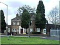
Health Centre, Marsh Lane
Distinctive building on north side of Marsh Lane, Erdington
Image: © Michael Westley
Taken: 25 Apr 2010
0.21 miles
3
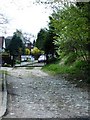
Gated road, Erdington
Hammond Drive (private road) in Erdington
Image: © Michael Westley
Taken: 25 Apr 2010
0.24 miles