IMAGES TAKEN NEAR TO
Sutton Road, BIRMINGHAM, B23 5TJ
Introduction
This page details the photographs taken nearby to Sutton Road, B23 5TJ by members of the Geograph project.
The Geograph project started in 2005 with the aim of publishing, organising and preserving representative images for every square kilometre of Great Britain, Ireland and the Isle of Man.

There are currently over 7.5m images from over14,400 individuals and you can help contribute to the project by visiting https://www.geograph.org.uk
Image Map
Images are licensed for reuse under creativecommons.org/licenses/by-sa/2.0
Notes
- Clicking on the map will re-center to the selected point.
- The higher the marker number, the further away the image location is from the centre of the postcode.
Image Listing (127 Images Found)
Images are licensed for reuse under creativecommons.org/licenses/by-sa/2.0
Image
Details
Distance
1
Midland Bank/HSBC Chester Road Branch 40-11-05
I worked for Midland Bank HSBC for 32 years and spent all but the last two in Birmingham Branches. I am photographing all the branches, or what's left of them, as they were when I joined Midland Bank in 1963. The branches all start with the sorting code 40-11.
This is the site of the Chester Road Branch. The sorting code was 40-11-05
Image: © Roy Hughes
Taken: 27 Dec 2008
0.02 miles
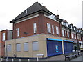
2
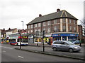
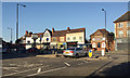
Broadfields Road meets Sutton Road, Wylde Green
Sutton Road and its continuation north as Birmingham Road are home to a well-used collection of shops. Traditional suburban staples (except for a butcher) have been absorbed into four convenience stores. While there are perhaps too many takeaways, hair salons, nail bars and coffee shops other services can be found: a pharmacy, a laundry, mobility devices, estate agents, a solicitor, a burgeoning florist, a café-bar, a travel agent and, of course, charity shops. The bus stop is for local service 89 towards Erdington; Sutton Road has frequent buses to and from Birmingham and points north.
Image: © Robin Stott
Taken: 15 Oct 2022
0.02 miles
3
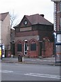
Historic building, Sutton Road, Wylde Green
Situated on Birmingham side of Birmingham / Sutton Coldfield boundary, between shops (shoe shop) and 2 storey residential flats, between Douay Road and Harman Road.
Its original purpose is believed to be as a tram terminus waiting room by H.H. Humphries, UDC Surveyor, 1910-11.(reference Pevsner's Buildings of England guide for Birmingham). Discussions on Birmingham History Forum's website appears to confirm this - even finding a map showing the building - https://images.birminghamhistory.co.uk/coppermine/albums/userpics/10011/map_c_1914_wylde_Green_showing_waiting_room.jpg
The building still contains working machinery involving 'Gas Board'.
The most recent transformation of the building, is from barbers, to small wine bar.
Image: © Michael Westley
Taken: 28 Nov 2009
0.02 miles
4
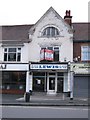
Former barbers shop, Sutton Road
Recently retired, the barbers' shop remains unused. Notice the stone above 2nd floor indicating 1906 as date the building was constructed.
Image: © Michael Westley
Taken: 28 Nov 2009
0.03 miles
5
Shops and flats above, Sutton Road, Erdington
Image: © Michael Westley
Taken: 28 Nov 2009
0.03 miles
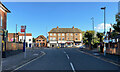
7
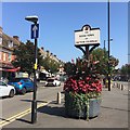
Announcing the Royal Town of Sutton Coldfield, Birmingham Road, Wylde Green
The centre of Sutton Coldfield is some 3 km to the north.
Image: © Robin Stott
Taken: 26 Aug 2019
0.04 miles
8
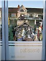
Nativity Scene and Reflection
Beautiful nativity scene in window of patisserie and delicatessen on Birmingham Road, Wylde Green, opposite restaurant and former barbers shop - see Image]
Image: © Michael Westley
Taken: 25 Dec 2009
0.04 miles
9
A summer evening in Wylde Green, north Birmingham
The shops in Sutton Road get the last of the sun. The parade left of centre is dated 1906. The shops on the right first appear on a map of 1937 (previous map 1921). The little building signed Barber Shop is a puzzle. On a map of 1914 there is a building here labelled Waiting Room (for buses or trams, perhaps?). In 1921 and 1937 the building is unlabelled but in 1963-5 it is identified as Lavs, and in 1970-75 as PCs (public conveniences). A sign centre left announces The Royal Town of Sutton Coldfield although it is 3km to Sutton town centre. The view is from Broadfields Road (which takes its name from a big old house, long gone). In 1889 there were fields where these shops are.
Image: © Robin Stott
Taken: 29 Jun 2018
0.04 miles
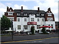
10
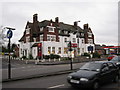
The Yenton, Public House, Sutton Road, Erdington
Pub on prominent main road location, at top of Douay Road. Renovated in the last year, it now provides good food as well as continuing to serve the 'football / sport' fraternity.
To this day, houses in the location, built on land once owned by the original brewers (M&B), have conditions in the deeds prohibiting the making and selling of alcoholic drinks.
Image: © Michael Westley
Taken: 28 Nov 2009
0.05 miles