IMAGES TAKEN NEAR TO
Somerton Drive, BIRMINGHAM, B23 5SU
Introduction
This page details the photographs taken nearby to Somerton Drive, B23 5SU by members of the Geograph project.
The Geograph project started in 2005 with the aim of publishing, organising and preserving representative images for every square kilometre of Great Britain, Ireland and the Isle of Man.

There are currently over 7.5m images from over14,400 individuals and you can help contribute to the project by visiting https://www.geograph.org.uk
Image Map
Images are licensed for reuse under creativecommons.org/licenses/by-sa/2.0
Notes
- Clicking on the map will re-center to the selected point.
- The higher the marker number, the further away the image location is from the centre of the postcode.
Image Listing (36 Images Found)
Images are licensed for reuse under creativecommons.org/licenses/by-sa/2.0
Image
Details
Distance
1
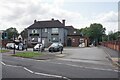
Rosey Mac's
The former Rose & Crown, now presenting itself as a sports bar and function venue.
Image: © Bill Boaden
Taken: 29 Jun 2023
0.04 miles
4
Convenience Store
Corner of Goosemoor Lane and Gravelly Lane - change of ownership since Image
Image: © Michael Westley
Taken: 14 Jan 2012
0.09 miles
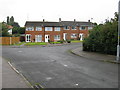
5
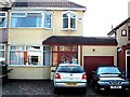
Bonsall Road
1930s house in Bonsall Road - a quiet cul-de-sac off the Gravelly Lane.
Image: © Paul Long
Taken: 1 Jul 2005
0.11 miles
6
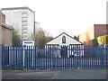
Place of Worship, Erdington
Erdington New Testament Church of God, sits almost hidden from view by passing motorists - next to Cookes, at junction of Gravelly Lane and Goosemoor Lane
Image: © Michael Westley
Taken: 14 Jan 2012
0.11 miles
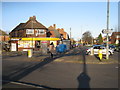
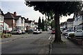
7

Goosemoor Lane junction with B4142 Gravelly Lane.
The family owned furniture superstore "Cookes" stands in Goosemoor Lane . The entrance is on the left just past the pillar box.
Image: © Roy Hughes
Taken: 21 Jan 2009
0.12 miles
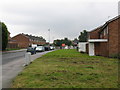
8
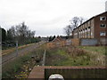
Lyndhurst Estate, cross city railway line
Taken from Banners Grove on the Lyndhurst Estate. Rear of decaying blocks of maisonettes are seen on right. In the distance can be seen the platforms of Chester Road station.
Image: © Michael Westley
Taken: 28 Nov 2009
0.16 miles
9
Knipersley Road, near Chester Road, north Birmingham
Image: © Robin Stott
Taken: 21 Aug 2019
0.16 miles
10
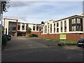
Fairlie House residential care home, Trident Close, north Birmingham
Run by SignHealth. A number of care categories can be provided for.
Image: © Robin Stott
Taken: 21 Aug 2019
0.17 miles