IMAGES TAKEN NEAR TO
Baldmoor Lake Road, BIRMINGHAM, B23 5PX
Introduction
This page details the photographs taken nearby to Baldmoor Lake Road, B23 5PX by members of the Geograph project.
The Geograph project started in 2005 with the aim of publishing, organising and preserving representative images for every square kilometre of Great Britain, Ireland and the Isle of Man.

There are currently over 7.5m images from over14,400 individuals and you can help contribute to the project by visiting https://www.geograph.org.uk
Image Map
Images are licensed for reuse under creativecommons.org/licenses/by-sa/2.0
Notes
- Clicking on the map will re-center to the selected point.
- The higher the marker number, the further away the image location is from the centre of the postcode.
Image Listing (17 Images Found)
Images are licensed for reuse under creativecommons.org/licenses/by-sa/2.0
Image
Details
Distance
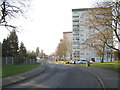
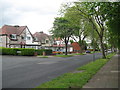
1
Repton House
Block of flats at the back of estate, north of Jarvis Road. Foreground was once part of a large allotments (now much smaller, off to the left)
Image: © Michael Westley
Taken: 14 Jan 2012
0.08 miles
2
Timberyard on Goosemoor Lane, Erdington
Formerly Sycamore Sawmills, reference to Sycamore Road nearby, the yard is now Travis Perkins, still a timberyard but also a builders suppliers
http://www.travisperkins.co.uk/
Domesday http://www.bbc.co.uk/history/domesday/dblock/GB-408000-291000
Image: © Michael Westley
Taken: 13 May 2011
0.13 miles
3

Goosemoor Lane junction with B4142 Gravelly Lane.
The family owned furniture superstore "Cookes" stands in Goosemoor Lane . The entrance is on the left just past the pillar box.
Image: © Roy Hughes
Taken: 21 Jan 2009
0.16 miles
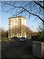
4
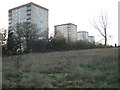
Jarvis Road flats
Four of five blocks of flats along Jarvis Road. From left, Berkeley House, Windsor House, Arundel House, Alnwick House. The land in foreground was once part of allotment gardens. Allotments still exist further off to the right
Image: © Michael Westley
Taken: 14 Jan 2012
0.16 miles
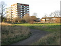
5
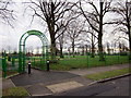
Roads of Erdington 3 - Birmingham
View east south east along Goosemoor Lane, Erdington at its junction with Bowling Green Close which is on the left. To the right is Short Heath Park, a public park with play area managed by Birmingham City Council. Time photo taken 2.24 pm BST (British Summer Time).
Image: © Martin Richard Phelan
Taken: 19 May 2015
0.17 miles
6
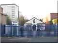
Place of Worship, Erdington
Erdington New Testament Church of God, sits almost hidden from view by passing motorists - next to Cookes, at junction of Gravelly Lane and Goosemoor Lane
Image: © Michael Westley
Taken: 14 Jan 2012
0.19 miles
7
Winter shadows
The trees are shadowed against walls of this block of flats, as the winter sun drops in the early evening
Image: © Michael Westley
Taken: 14 Jan 2012
0.19 miles
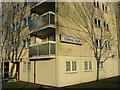
8
Stokesay House, Erdington
Most easterly block of flats on Jarvis Road, from corner of cul-de-sac on south side of Jarvis Road
Image: © Michael Westley
Taken: 14 Jan 2012
0.19 miles
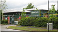
9
Short Heath Park Erdington, Court Lane Entrance
Image: © Roy Hughes
Taken: 25 Dec 2011
0.20 miles