IMAGES TAKEN NEAR TO
Witton Lodge Road, BIRMINGHAM, B23 5LH
Introduction
This page details the photographs taken nearby to Witton Lodge Road, B23 5LH by members of the Geograph project.
The Geograph project started in 2005 with the aim of publishing, organising and preserving representative images for every square kilometre of Great Britain, Ireland and the Isle of Man.

There are currently over 7.5m images from over14,400 individuals and you can help contribute to the project by visiting https://www.geograph.org.uk
Image Map
Images are licensed for reuse under creativecommons.org/licenses/by-sa/2.0
Notes
- Clicking on the map will re-center to the selected point.
- The higher the marker number, the further away the image location is from the centre of the postcode.
Image Listing (29 Images Found)
Images are licensed for reuse under creativecommons.org/licenses/by-sa/2.0
Image
Details
Distance
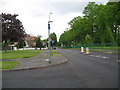
1
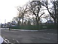
The Spinney, Witton Lodge Road, Number 7 Bus Terminus
Taken from Court Lane looking towards The Spinney (as it is known locally). The Number 7 bus terminates here before returning to Birmingham city centre.
Image: © Roy Hughes
Taken: 6 Jan 2009
0.07 miles
2

Midday Christmas 2011 - No Buses Today!
Witton Lodge Road, Erdington, bus terminus for the numbers 7 and 65 routes
Image: © Roy Hughes
Taken: 25 Dec 2011
0.09 miles
3
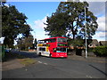
Bus on Court Lane, Perry Common
A bus moves from the arrival stop at Perry Common terminus to the departure stop by way of Court Lane. Both routes that terminate here, the 7 and the 65, approach along Witton Lodge Road, which splits into two to pass either side of a small, fenced off, patch of woodland (see Image) as it nears Court Lane. This provides a convenient means by which the buses can turn round. The 65, on which this bus is operating, is a more direct but less frequent route into Birmingham city centre than the 7.
Image: © Richard Vince
Taken: 7 Oct 2011
0.11 miles
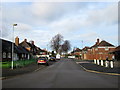
4
Midday Christmas 2012 :: Flackwell Road Erdington
Flackwell Road at crossroad with Chipstead Road Erdington, Midday Christmas 2012
Image: © Roy Hughes
Taken: 25 Dec 2012
0.14 miles
5
Midday Christmas 2013 Chipstead Road & Flackwell Road Crossroads Erdington
Image: © Roy Hughes
Taken: 25 Dec 2013
0.15 miles
6
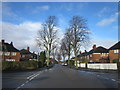
Roads of Erdington 1 - Birmingham
View north along Court Lane, Erdington from its junction with Jerry's Lane and Harcourt Road. On the right of this view is Short Heath Park, a public park with play area managed by Birmingham City Council. Time photo taken 1.54 pm BST (British Summer Time).
Image: © Martin Richard Phelan
Taken: 19 May 2015
0.15 miles
7
Midday Christmas 2013 Flackwell Road Erdington
Image: © Roy Hughes
Taken: 25 Dec 2013
0.17 miles
8
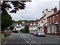
Court Lane
Looking north, at the point where the road leaves Birmingham and enters Sutton.
Image: © Adrian Bailey
Taken: 17 Jun 2005
0.17 miles
9
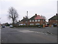
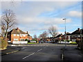
Chipstead Road/Flackwell Road Crossroads - Erdington
Showing the crossroads on this estate built in the late 1930s, Erdington, Birmingham B23.
Image: © Roy Hughes
Taken: 30 Dec 2008
0.17 miles
10

Erdington: Jerrys Lane Post Office
An unusual situation of a new post office branch opening - not a replacement for a nearby closure but a brand new branch, within the One Stop convenience store in Jerrys Lane. It opened at the end of May 2016.
The post office counter is alongside the retail counter and this is therefore one of now hundreds of branches where post office services are available throughout the store's opening hours. In this case, these are 7am-10pm seven days a week.
Image: © Chris Downer
Taken: 14 Aug 2016
0.18 miles