IMAGES TAKEN NEAR TO
BIRMINGHAM, B2 2FJ
Introduction
This page details the photographs taken nearby to B2 2FJ by members of the Geograph project.
The Geograph project started in 2005 with the aim of publishing, organising and preserving representative images for every square kilometre of Great Britain, Ireland and the Isle of Man.

There are currently over 7.5m images from over14,400 individuals and you can help contribute to the project by visiting https://www.geograph.org.uk
Image Map
Images are licensed for reuse under creativecommons.org/licenses/by-sa/2.0
Notes
- Clicking on the map will re-center to the selected point.
- The higher the marker number, the further away the image location is from the centre of the postcode.
Image Listing (26 Images Found)
Images are licensed for reuse under creativecommons.org/licenses/by-sa/2.0
Image
Details
Distance
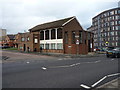
1
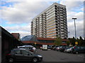
Newtown Shopping Centre, Newtown
Located immediately to the west of the A34 as it heads north from Birmingham towards Walsall, Newtown Shopping Centre appeared to have been a recent recipient of refurbishment work, and was generally a surprisingly pleasant place to be. The low buildings of the shopping centre are dwarfed by the vast bulk of Inkerman House, which actually sits atop the eastern extremity of the centre.
Image: © Richard Vince
Taken: 26 Oct 2013
0.13 miles
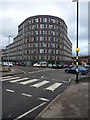
2
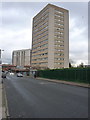
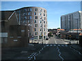
Baldwin House
A 15-storey block of flats on Summer Lane in Newtown.
Image: © Richard Law
Taken: 1 Feb 2017
0.13 miles
3
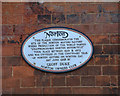
Norton Factory Plaque
Plaque on the wall of the T A Savery & Co Ltd, Newcomen Works, Bracebridge Street.
Image: © Jeff Tomlinson
Taken: 2 Jun 2002
0.13 miles
4
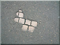
Cobbles beneath the surface of Bracebridge Street
Image: © Jeff Tomlinson
Taken: 2 Jun 2002
0.13 miles
5
Another derelict factory
The old Crocodile Works in Alma Street.
Image: © Carl Baker
Taken: 5 Sep 2006
0.13 miles
6
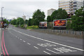
High Street, Newtown
Not really anybody's idea of a High Street, this is a stretch of the A34 heading into central Birmingham.
Image: © Stephen McKay
Taken: 27 May 2017
0.14 miles
7
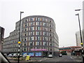
Southern end of the Crocodile Works development
The remains of the former Crocodile Works factory on Alma Street has been converted to flats, and this imposing round-nosed frontage built onto it between Alma and Porchester Streets.
Image: © Richard Law
Taken: 1 Feb 2017
0.15 miles
8
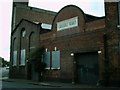
The Summer Lane Church of Christ
A fairly new church on the corner of Geach Street with Summer Lane www.summerlanecoc.com
Image: © Richard Law
Taken: 1 Feb 2017
0.16 miles
9
Flats and shops, north end of Summer Lane B19
On the left is the junction with Geach Street and an unidentified place of worship. Beyond it is the junction with Porchester Street where Summer Lane becomes Alma Street.
Image: © Robin Stott
Taken: 10 Aug 2012
0.16 miles
10
Crocodile Works, But Now Flats
Image: © Roy Hughes
Taken: 28 Feb 2012
0.16 miles