IMAGES TAKEN NEAR TO
Farcroft Grove, BIRMINGHAM, B21 8PU
Introduction
This page details the photographs taken nearby to Farcroft Grove, B21 8PU by members of the Geograph project.
The Geograph project started in 2005 with the aim of publishing, organising and preserving representative images for every square kilometre of Great Britain, Ireland and the Isle of Man.

There are currently over 7.5m images from over14,400 individuals and you can help contribute to the project by visiting https://www.geograph.org.uk
Image Map
Images are licensed for reuse under creativecommons.org/licenses/by-sa/2.0
Notes
- Clicking on the map will re-center to the selected point.
- The higher the marker number, the further away the image location is from the centre of the postcode.
Image Listing (7 Images Found)
Images are licensed for reuse under creativecommons.org/licenses/by-sa/2.0
Image
Details
Distance
2
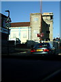
Gurdwara Bebe Nanaki Ji, Handsworth
Construction underway on Rookery Road, Handsworth
Image: © Michael Westley
Taken: 17 Jan 2010
0.17 miles
3
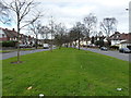
Sandwell Road dual carriageway
A view down the grassy central reservation of the A4040 through Handsworth.
Image: © Richard Law
Taken: 8 Mar 2017
0.20 miles
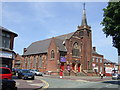
4

Trinity Methodist Church, Handsworth
Church on Rookery Road, Handsworth close to junction with Oxhill Road.
Image: © Michael Westley
Taken: 17 Jan 2010
0.21 miles
6
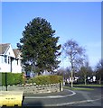
Corner of Cranbrook Rd and Sandwell Rd
Araucaria araucana
Image: © araucaria araucana
Taken: 19 Jan 2011
0.24 miles
7
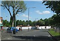
The Uplands Pub Site, Now Demolished
I must have passed this pub a thousand times and never took a picture of it before it was torn down.
Image: © Roy Hughes
Taken: 12 May 2009
0.25 miles