IMAGES TAKEN NEAR TO
Wenlock Road, BIRMINGHAM, B20 3HW
Introduction
This page details the photographs taken nearby to Wenlock Road, B20 3HW by members of the Geograph project.
The Geograph project started in 2005 with the aim of publishing, organising and preserving representative images for every square kilometre of Great Britain, Ireland and the Isle of Man.

There are currently over 7.5m images from over14,400 individuals and you can help contribute to the project by visiting https://www.geograph.org.uk
Image Map
Images are licensed for reuse under creativecommons.org/licenses/by-sa/2.0
Notes
- Clicking on the map will re-center to the selected point.
- The higher the marker number, the further away the image location is from the centre of the postcode.
Image Listing (58 Images Found)
Images are licensed for reuse under creativecommons.org/licenses/by-sa/2.0
Image
Details
Distance
1
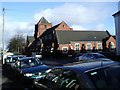
Church of God, Wenlock Road, Birchfield
Church on Wenlock Road, at corner with Norris Road.
Image: © Michael Westley
Taken: 17 Jan 2010
0.02 miles
2
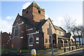
All Souls Church, Wenlock Road/Nelson Road junction
There is an OS benchmark Image between the north facing buttress and the next buttress to its right on the Wenlock Road face of the church.
Image: © Roger Templeman
Taken: 10 Nov 2012
0.03 miles
3
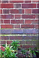
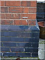
Benchmark on All Souls Church, Wenlock Road
Ordnance Survey cut mark benchmark described on the Bench Mark Database at http://www.bench-marks.org.uk/bm46135
Image: © Roger Templeman
Taken: 10 Nov 2012
0.03 miles
4

Villa Park
A football stadium. Here it is in action as Aston Villa, the home team, somehow haplessly beat Norwich City, the visiting team
Image: © Ainsley Bennett
Taken: Unknown
0.06 miles
5
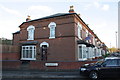
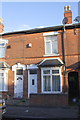
#87 Kenilworth Road
There is an OS benchmark Image on the front right corner of the house which is at the junction of Kenilworth Road and The Broadway
Image: © Roger Templeman
Taken: 10 Nov 2012
0.08 miles
6
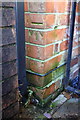
Benchmark on #87 Kenilworth Road
Ordnance Survey cut mark benchmark described on the Bench Mark Database at http://www.bench-marks.org.uk/bm46127
Image: © Roger Templeman
Taken: 10 Nov 2012
0.08 miles
7
Benchmark on #37 Kenilworth Road
Ordnance Survey cut mark benchmark described on the Bench Mark Database at http://www.bench-marks.org.uk/bm46129
Image: © Roger Templeman
Taken: 10 Nov 2012
0.09 miles
8
#37 Kenilworth Road
There is an OS benchmark Image on the corner of the house next to the metal gate
Image: © Roger Templeman
Taken: 10 Nov 2012
0.09 miles
9
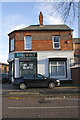
#270 Aston Lane, 'inspired hair & beauty' salon
There is an OS benchmark Image on the white wall behind the parked car
Image: © Roger Templeman
Taken: 10 Nov 2012
0.12 miles
10
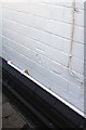
Benchmark on #270 Aston Lane (Wenlock Road face)
Ordnance Survey cut mark benchmark described on the Bench Mark Database at http://www.bench-marks.org.uk/bm40042
Image: © Roger Templeman
Taken: 10 Nov 2012
0.12 miles