IMAGES TAKEN NEAR TO
Stoneleigh Road, BIRMINGHAM, B20 3AS
Introduction
This page details the photographs taken nearby to Stoneleigh Road, B20 3AS by members of the Geograph project.
The Geograph project started in 2005 with the aim of publishing, organising and preserving representative images for every square kilometre of Great Britain, Ireland and the Isle of Man.

There are currently over 7.5m images from over14,400 individuals and you can help contribute to the project by visiting https://www.geograph.org.uk
Image Map
Images are licensed for reuse under creativecommons.org/licenses/by-sa/2.0
Notes
- Clicking on the map will re-center to the selected point.
- The higher the marker number, the further away the image location is from the centre of the postcode.
Image Listing (34 Images Found)
Images are licensed for reuse under creativecommons.org/licenses/by-sa/2.0
Image
Details
Distance
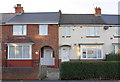
1
Houses on Stoneleigh Road
There is an OS benchmark Image on the front near corner of the nearest house (#125)
Image: © Roger Templeman
Taken: 10 Nov 2012
0.03 miles
2
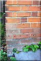
Benchmark on #125 Stoneleigh Road
Ordnance Survey cut mark benchmark described on the Bench Mark Database at http://www.bench-marks.org.uk/bm46123
Image: © Roger Templeman
Taken: 10 Nov 2012
0.03 miles
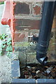
3
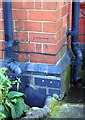
Benchmark on #140 Aston Lane
Ordnance Survey cut mark benchmark described on the Bench Mark Database at http://www.bench-marks.org.uk/bm40044
Image: © Roger Templeman
Taken: 10 Nov 2012
0.08 miles
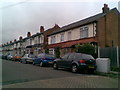
4
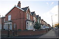
Row of houses on Aston Lane
There is an OS benchmark Image on the near corner, between the two black downpipes, of the nearest house, #140
Image: © Roger Templeman
Taken: 10 Nov 2012
0.08 miles
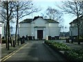
5
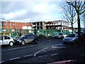
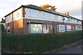
Broadway School, The Broadway, Perry Barr
Redevelopment of school buildings on 'The Broadway', between Perry Barr and Witton.
Image: © Michael Westley
Taken: 17 Jan 2010
0.09 miles
6
Benchmark on side of porch of #75 Stoneleigh Road
Ordnance Survey cut mark benchmark described on the Bench Mark Database at http://www.bench-marks.org.uk/bm46122
Image: © Roger Templeman
Taken: 10 Nov 2012
0.11 miles
7
#75 and #77 Stoneleigh Road
There is an OS benchmark Image on the side of the porch of #75 and above the path to the door of #77
Image: © Roger Templeman
Taken: 10 Nov 2012
0.11 miles
8
Thornbury Road
Edwardian houses in Aston.
Image: © Burgess Von Thunen
Taken: 28 Sep 2010
0.13 miles
9
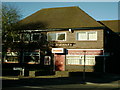
The Harriers pub
On the junction of The Broadway and Davey Road.
Image: © Carl Baker
Taken: 2 Nov 2006
0.13 miles
10
Former IMI entrance, Perry Barr
Opposite entrance to University the buildings remain whilst land behind is unused.
Image: © Michael Westley
Taken: 17 Jan 2010
0.16 miles