IMAGES TAKEN NEAR TO
Grestone Avenue, BIRMINGHAM, B20 1AR
Introduction
This page details the photographs taken nearby to Grestone Avenue, B20 1AR by members of the Geograph project.
The Geograph project started in 2005 with the aim of publishing, organising and preserving representative images for every square kilometre of Great Britain, Ireland and the Isle of Man.

There are currently over 7.5m images from over14,400 individuals and you can help contribute to the project by visiting https://www.geograph.org.uk
Image Map
Images are licensed for reuse under creativecommons.org/licenses/by-sa/2.0
Notes
- Clicking on the map will re-center to the selected point.
- The higher the marker number, the further away the image location is from the centre of the postcode.
Image Listing (10 Images Found)
Images are licensed for reuse under creativecommons.org/licenses/by-sa/2.0
Image
Details
Distance
1
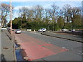
Junction of College Road with Friary Road
Here College Road from the SSE joins Friary Road, where it runs between Handsworth and Brown's Green.
Image: © Richard Law
Taken: 8 Mar 2017
0.08 miles
2
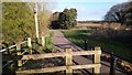
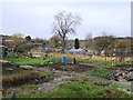
Silvercroft
Silvercroft Avenue entry into the Sandwell Valley
Image: © Frank Bruce
Taken: 29 Mar 2020
0.09 miles
3
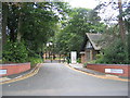
Entrance to Handsworth Hall
Handsworth Hall was built in Tudor perpendicular style in 1881 as a Wesleyan Methodist theological college. Today it is part of the UCE. This is the entrance from Friary Road, although most of the main buildings, just visible through the trees, are in the adjacent square.
Image: © David Stowell
Taken: 9 Jul 2006
0.15 miles
5
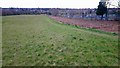
Friary Road from Sandwell Valley
Looking South to Friary Road and Uplands Allotments from the Sandwell Valley
Image: © Frank Bruce
Taken: 29 Mar 2020
0.19 miles
8
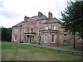
Hawthorne House, Handsworth
Hawthorne House was originally a Georgian building however it was heavily altered in Victorian times with further additions in the early 19th Century. In 1841 it was the home of Bullock the ironmaster who had a foundry in West Bromwich. It is a listed building and is now used as a public library.
Image: © David Stowell
Taken: 9 Jul 2006
0.20 miles
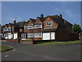
9
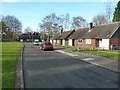
Bungalows on May Tree Grove
Rather suspect this is some sort of sheltered housing scheme.
Image: © Richard Law
Taken: 8 Mar 2017
0.22 miles
10
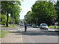
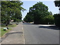
Friary Road, Handsworth Towards Browns Green
Image: © Roy Hughes
Taken: 12 May 2009
0.22 miles