IMAGES TAKEN NEAR TO
Dudley Road, BIRMINGHAM, B18 7QY
Introduction
This page details the photographs taken nearby to Dudley Road, B18 7QY by members of the Geograph project.
The Geograph project started in 2005 with the aim of publishing, organising and preserving representative images for every square kilometre of Great Britain, Ireland and the Isle of Man.

There are currently over 7.5m images from over14,400 individuals and you can help contribute to the project by visiting https://www.geograph.org.uk
Image Map
Images are licensed for reuse under creativecommons.org/licenses/by-sa/2.0
Notes
- Clicking on the map will re-center to the selected point.
- The higher the marker number, the further away the image location is from the centre of the postcode.
Image Listing (63 Images Found)
Images are licensed for reuse under creativecommons.org/licenses/by-sa/2.0
Image
Details
Distance
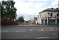
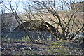
3
Heath Street, Winson Green
Off Dudley Road.
Image: © Richard Vince
Taken: 3 Dec 2022
0.04 miles
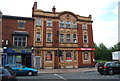
4
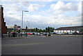
Junction of Winson Green Rd and Dudley Rd
Image: © N Chadwick
Taken: 10 Jun 2011
0.05 miles
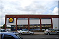
6
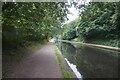
Birmingham New Main Line Canal
Towards Lee Bridge.
Image: © Ian S
Taken: 25 Jul 2021
0.07 miles
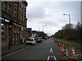
7
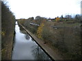
Birmingham Main Line Canal, Winson Green
Looking towards Wolverhampton from the bridge carrying Dudley Road across it, with a class 350 electric unit of London Northwestern Railway travelling along the parallel railway line.
Image: © Richard Vince
Taken: 3 Dec 2022
0.07 miles