IMAGES TAKEN NEAR TO
New Spring Gardens, BIRMINGHAM, B18 7LN
Introduction
This page details the photographs taken nearby to New Spring Gardens, B18 7LN by members of the Geograph project.
The Geograph project started in 2005 with the aim of publishing, organising and preserving representative images for every square kilometre of Great Britain, Ireland and the Isle of Man.

There are currently over 7.5m images from over14,400 individuals and you can help contribute to the project by visiting https://www.geograph.org.uk
Image Map
Images are licensed for reuse under creativecommons.org/licenses/by-sa/2.0
Notes
- Clicking on the map will re-center to the selected point.
- The higher the marker number, the further away the image location is from the centre of the postcode.
Image Listing (58 Images Found)
Images are licensed for reuse under creativecommons.org/licenses/by-sa/2.0
Image
Details
Distance
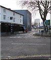
1
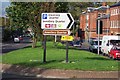
Icknield Street A4540
...looking north from the junction with Vyse Street. On the right is the Birmingham Mint.
Image: © Adrian Bailey
Taken: 30 Sep 2004
0.10 miles
2
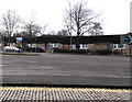
Icknield Street bungalows, Birmingham
On the west side of the A4540, here named Icknield Street.
Image: © Jaggery
Taken: 23 Jan 2018
0.11 miles
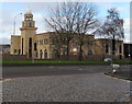
3
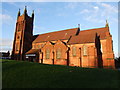
New Testament Church of God the Rock, Hockley
Image: © Chris Whippet
Taken: 22 Dec 2013
0.11 miles
4
Hingeston Street mosque from Icknield Street
Not appearing in directories of Birmingham mosques at the time of submission, so it is not known what branch of Islam is worshipped here – if it is indeed a mosque.
Image: © Robin Stott
Taken: 5 Dec 2012
0.13 miles
5
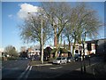
Icknield Street A4540, junction with Warstone Lane
Prominent in the background is the 40-metre chimney of the former Birmingham Mint, now being redeveloped.
From the Wikipedia article about the Jewellery Quarter http://en.wikipedia.org/wiki/Jewellery_Quarter –
…on the fringe of the Jewellery Quarter is the Birmingham Mint redevelopment by Junared Property Group. When the Mint closed in 2003, work got underway to find an alternative use for the site. Demolition work on the site commenced in early 2007 and construction in September 2007. The scheme has been designed by Ian Darby Partnership and is being developed in two phases. Phase 1 will include 192 apartments and approximately 60,000 square feet (5,574 m2) of offices whilst Phase 2 will consist of 62 apartments and a 50,000-square-foot (4,645 m2) data centre is now in the planning stage. Ninex are constructing the complex. As part of the scheme, the Grade II listed façade and the 130-foot (40 m) chimney are being retained and incorporated.
Image: © Robin Stott
Taken: 5 Dec 2012
0.13 miles
6
Burhani Saifee Icknield Mosque, Birmingham
Viewed across the A4540 Icknield Street.
Image: © Jaggery
Taken: 23 Jan 2018
0.13 miles
7
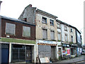
Dereliction on Icknield Street, Birmingham
This 2008 view shows a well known row of derelict shops situated at the junction of Warstone Lane and Icknield Street. The official address of the New Rimini Cafe was 114 Icknield Street (ref: The National Archives 99/00461). The shops to the right included a sports shop, newsagent and a Chinese takeaway. (ref: The National Archives AA99/02967)
The entire row of shops shown here has since been demolished to make way for a new mixed use development. Despite the historical significance of these former back to back houses, no attempt was made to save them.
Image: © vectorkraft
Taken: 7 Feb 2008
0.14 miles
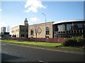
8
City View
Looking towards the BT Tower in Birmingham City centre from Knightstone Avenue.
Image: © Carl Baker
Taken: 9 Oct 2006
0.14 miles
9
Viceroy and Klassic Grill, Icknield Street, Birmingham
Viceroy Bangladeshi cuisine restaurant is next door to Klassic Grill Afro cuisine.
Image: © Jaggery
Taken: 23 Jan 2018
0.14 miles
10
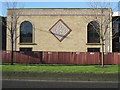
Decoration, Hingeston Street mosque
Not appearing in directories of Birmingham mosques at the time of submission, so it is not known what branch of Islam is worshipped here – if it is indeed a mosque.
Image: © Robin Stott
Taken: 5 Dec 2012
0.14 miles