IMAGES TAKEN NEAR TO
Glass Way, B18 7BG
Introduction
This page details the photographs taken nearby to Glass Way, B18 7BG by members of the Geograph project.
The Geograph project started in 2005 with the aim of publishing, organising and preserving representative images for every square kilometre of Great Britain, Ireland and the Isle of Man.

There are currently over 7.5m images from over14,400 individuals and you can help contribute to the project by visiting https://www.geograph.org.uk
Image Map
Images are licensed for reuse under creativecommons.org/licenses/by-sa/2.0
Notes
- Clicking on the map will re-center to the selected point.
- The higher the marker number, the further away the image location is from the centre of the postcode.
Image Listing (46 Images Found)
Images are licensed for reuse under creativecommons.org/licenses/by-sa/2.0
Image
Details
Distance
1
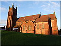
New Testament Church of God the Rock, Hockley
Image: © Chris Whippet
Taken: 22 Dec 2013
0.06 miles
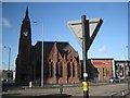
2
Spring Hill Library, Hockley Birmingham
The foundation stone for this library was laid in April 1891. The library was designed by the Birmingham architects Martin & Chamberlain and built by Sapcote & Sons at a cost (including fittings) of £5,996. It is constructed of red brick and terracotta with a clock tower 65 feet high. The interior vaulted space is 48 by 43 feet with a gallery running along two sides. Well worth a visit.
Image: © Roy Hughes
Taken: 25 Oct 2011
0.07 miles
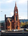
3
Spring Hill Library in the shadow of Canterbury Tower
For a fine portrait and description of the library see http://www.geograph.org.uk/p/2667079 A little further away, left, is the tower of St Peter's Church, Spring Hill, now in use by the New Testament Church of God, the Rock.
Image: © Robin Stott
Taken: 5 Dec 2012
0.08 miles
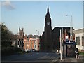
4
Spring Hill Library: the setting
Looking satanic in the shadow of a block of flats, this riveting building is surrounded on two sides by a supermarket and on the other two sides by wide, busy roads and street furniture. This is the view across A4540 Icknield Street. This east frontage waits to be photographed in better light, perhaps earlier in the day. There is an image in Bill Dargue's History of Birmingham Places and Placenames http://billdargue.jimdo.com/placenames-gazetteer-a-to-y/places-s/spring-hill/ For a well-lit view of the south side and a description see http://www.geograph.org.uk/p/2667079
Image: © Robin Stott
Taken: 5 Dec 2012
0.08 miles
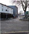
5
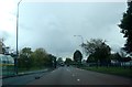
Ladywood Middleway
The dual carriageway at Ladywood which forms part of the Birmingham middle ring road. Viewed looking towards the canal and railway which pass beneath this road near the location of the bus in the picture.
Image: © Rob Newman
Taken: 7 Oct 2011
0.09 miles
6
Icknield Street A4540
...looking north from the junction with Vyse Street. On the right is the Birmingham Mint.
Image: © Adrian Bailey
Taken: 30 Sep 2004
0.11 miles
7
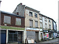
Dereliction on Icknield Street, Birmingham
This 2008 view shows a well known row of derelict shops situated at the junction of Warstone Lane and Icknield Street. The official address of the New Rimini Cafe was 114 Icknield Street (ref: The National Archives 99/00461). The shops to the right included a sports shop, newsagent and a Chinese takeaway. (ref: The National Archives AA99/02967)
The entire row of shops shown here has since been demolished to make way for a new mixed use development. Despite the historical significance of these former back to back houses, no attempt was made to save them.
Image: © vectorkraft
Taken: 7 Feb 2008
0.17 miles
8
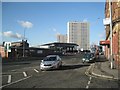
Summer Hill Road, Ladywood, from the corner of Powell Street
The building in the centre is the Sytner BMW Mini car showroom. The nearest block of flats is the Canterbury Tower with the Salisbury Tower beyond it.
Image: © Robin Stott
Taken: 5 Dec 2012
0.17 miles
9
Viceroy and Klassic Grill, Icknield Street, Birmingham
Viceroy Bangladeshi cuisine restaurant is next door to Klassic Grill Afro cuisine.
Image: © Jaggery
Taken: 23 Jan 2018
0.17 miles
10
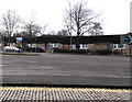
Icknield Street bungalows, Birmingham
On the west side of the A4540, here named Icknield Street.
Image: © Jaggery
Taken: 23 Jan 2018
0.17 miles