IMAGES TAKEN NEAR TO
The Triangle, Allens Road, BIRMINGHAM, B18 4QU
Introduction
This page details the photographs taken nearby to The Triangle, Allens Road, B18 4QU by members of the Geograph project.
The Geograph project started in 2005 with the aim of publishing, organising and preserving representative images for every square kilometre of Great Britain, Ireland and the Isle of Man.

There are currently over 7.5m images from over14,400 individuals and you can help contribute to the project by visiting https://www.geograph.org.uk
Image Map
Images are licensed for reuse under creativecommons.org/licenses/by-sa/2.0
Notes
- Clicking on the map will re-center to the selected point.
- The higher the marker number, the further away the image location is from the centre of the postcode.
Image Listing (53 Images Found)
Images are licensed for reuse under creativecommons.org/licenses/by-sa/2.0
Image
Details
Distance
1
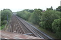
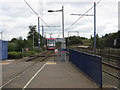
Crossing the Midland Metro and railway
In Handsworth
Image: © Andrew Abbott
Taken: 25 May 2019
0.02 miles
2
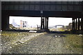
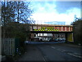
Snow Hill approach - Bacchus Road
Bacchus Road bridge across GWR line. Remains of goods station in distance on left. See Image
LNWR line bridge crossing route of GWR in distance on right.
Image: © Michael Westley
Taken: Unknown
0.03 miles
3

Unscheduled Stop
The tram brought down the overhead lines at the start of the rush-hour. Passengers were evacuated by walking several hundred metres along the track. No assistance was given to the elderly, disabled or a woman with child and baby buggy. Problems didn't finish there as the main bus service runs along the Soho Road another 600m away.
Image: © John M
Taken: 3 Jun 2015
0.03 miles
4
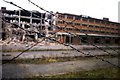
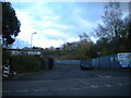
Snow Hill approach - Winson Green Goods Station
Former goods station, west of Baccus Road partially demolished. This building stood close to where the current loop line between Winson Green and Perry Barr crosses the former GWR line. See Image
The location is now a business park.
Image: © Michael Westley
Taken: Unknown
0.06 miles
5
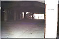
Snow Hill approach - Winson Green Goods
One of the floors of former goods station - notice the sign on wall 'Nottingh', indicating destination for goods from bay/location. Lift shaft / stairs are in background.
Image: © Michael Westley
Taken: Unknown
0.06 miles
6

Snow Hill approach - Winson Green Goods Station
Former goods station, semi demolished - close up
Image: © Michael Westley
Taken: Unknown
0.06 miles
7
Midland Metro tram leaving Winson Green station
Image: © Peter Whatley
Taken: 29 Sep 2008
0.13 miles
8
Bridge across Handsworth New Road, Winson Green
Carrying the Birmingham Snow Hill to Stourbridge railway line and the West Midlands Metro. Visible just beyond the bridge is the junction where Nineveh Road heads off to the right, while the main road continues as Boulton Road.
Image: © Richard Vince
Taken: 19 Nov 2022
0.14 miles
9
Great Western Close, Winson Green
Leading to an industrial estate off Handsworth New Road.
Image: © Richard Vince
Taken: 19 Nov 2022
0.15 miles
10
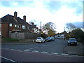
Reynolds Road, Handsworth
Off Boulton Road.
Image: © Richard Vince
Taken: 19 Nov 2022
0.15 miles